You are here: Home > Network List > TA - USArray Transportable Network (new EarthScope stations) Stations List
> Station X33A Lawton, OK, USA > Earthquake Result Viewer
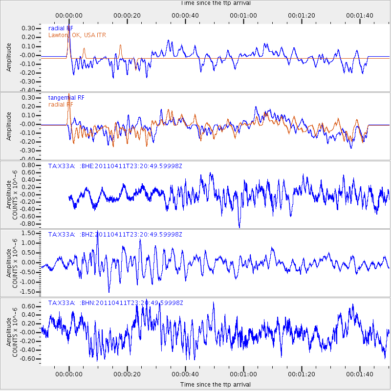
X33A Lawton, OK, USA - Earthquake Result Viewer
*The percent match for this event was below the threshold and hence no stack was calculated.
| Earthquake location: |
Near East Coast Of Honshu, Japan |
| Earthquake latitude/longitude: |
35.4/140.6 |
| Earthquake time(UTC): |
2011/04/11 (101) 23:08:16 GMT |
| Earthquake Depth: |
15 km |
| Earthquake Magnitude: |
6.0 MB, 6.1 MS, 6.2 MW, 6.2 MW |
| Earthquake Catalog/Contributor: |
WHDF/NEIC |
|
| Network: |
TA USArray Transportable Network (new EarthScope stations) |
| Station: |
X33A Lawton, OK, USA |
| Lat/Lon: |
34.54 N/98.50 W |
| Elevation: |
346 m |
|
| Distance: |
91.2 deg |
| Az: |
45.097 deg |
| Baz: |
315.506 deg |
| Ray Param: |
$rayparam |
*The percent match for this event was below the threshold and hence was not used in the summary stack. |
|
| Radial Match: |
54.96653 % |
| Radial Bump: |
400 |
| Transverse Match: |
44.544403 % |
| Transverse Bump: |
400 |
| SOD ConfigId: |
356183 |
| Insert Time: |
2011-09-27 10:13:21.140 +0000 |
| GWidth: |
2.5 |
| Max Bumps: |
400 |
| Tol: |
0.001 |
|
Signal To Noise
| Channel | StoN | STA | LTA |
| TA:X33A: :BHZ:20110411T23:20:49.59998Z | 2.4149485 | 3.027252E-7 | 1.2535472E-7 |
| TA:X33A: :BHN:20110411T23:20:49.59998Z | 0.9919227 | 3.8663796E-7 | 3.8978638E-7 |
| TA:X33A: :BHE:20110411T23:20:49.59998Z | 1.219597 | 1.7472456E-7 | 1.4326417E-7 |
| Arrivals |
| Ps | |
| PpPs | |
| PsPs/PpSs | |


