You are here: Home > Network List > TA - USArray Transportable Network (new EarthScope stations) Stations List
> Station 334A Lometa, TX, USA > Earthquake Result Viewer
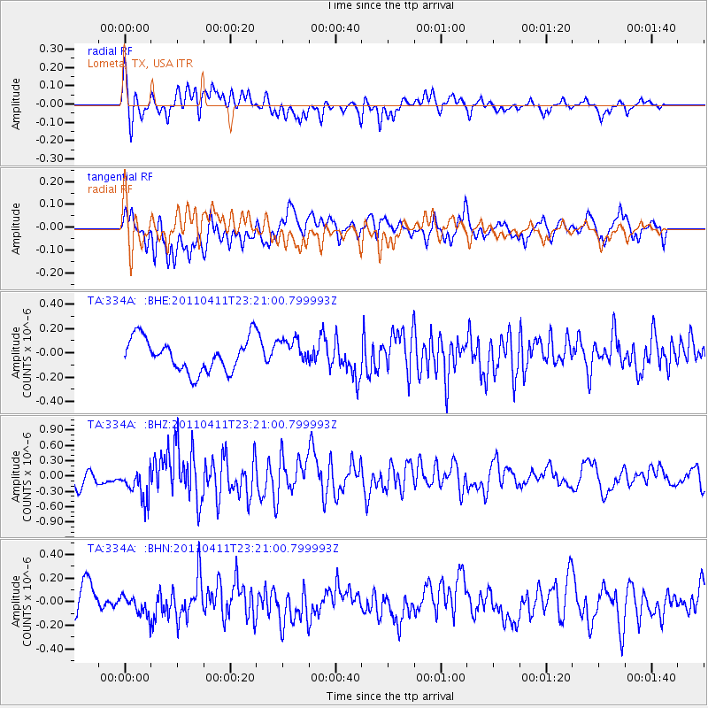
334A Lometa, TX, USA - Earthquake Result Viewer
*The percent match for this event was below the threshold and hence no stack was calculated.
| Earthquake location: |
Near East Coast Of Honshu, Japan |
| Earthquake latitude/longitude: |
35.4/140.6 |
| Earthquake time(UTC): |
2011/04/11 (101) 23:08:16 GMT |
| Earthquake Depth: |
15 km |
| Earthquake Magnitude: |
6.0 MB, 6.1 MS, 6.2 MW, 6.2 MW |
| Earthquake Catalog/Contributor: |
WHDF/NEIC |
|
| Network: |
TA USArray Transportable Network (new EarthScope stations) |
| Station: |
334A Lometa, TX, USA |
| Lat/Lon: |
31.33 N/98.24 W |
| Elevation: |
389 m |
|
| Distance: |
93.6 deg |
| Az: |
47.182 deg |
| Baz: |
315.561 deg |
| Ray Param: |
$rayparam |
*The percent match for this event was below the threshold and hence was not used in the summary stack. |
|
| Radial Match: |
77.27731 % |
| Radial Bump: |
400 |
| Transverse Match: |
51.92622 % |
| Transverse Bump: |
400 |
| SOD ConfigId: |
356183 |
| Insert Time: |
2011-09-27 10:19:49.702 +0000 |
| GWidth: |
2.5 |
| Max Bumps: |
400 |
| Tol: |
0.001 |
|
Signal To Noise
| Channel | StoN | STA | LTA |
| TA:334A: :BHZ:20110411T23:21:00.799993Z | 1.9404684 | 3.1581445E-7 | 1.6275165E-7 |
| TA:334A: :BHN:20110411T23:21:00.799993Z | 0.6751255 | 8.6804754E-8 | 1.2857573E-7 |
| TA:334A: :BHE:20110411T23:21:00.799993Z | 0.7974653 | 1.0755419E-7 | 1.3487005E-7 |
| Arrivals |
| Ps | |
| PpPs | |
| PsPs/PpSs | |


