You are here: Home > Network List > TA - USArray Transportable Network (new EarthScope stations) Stations List
> Station T34A McClaskey Farms, Geuda Springs, KS, USA > Earthquake Result Viewer
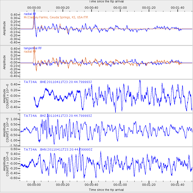
T34A McClaskey Farms, Geuda Springs, KS, USA - Earthquake Result Viewer
*The percent match for this event was below the threshold and hence no stack was calculated.
| Earthquake location: |
Near East Coast Of Honshu, Japan |
| Earthquake latitude/longitude: |
35.4/140.6 |
| Earthquake time(UTC): |
2011/04/11 (101) 23:08:16 GMT |
| Earthquake Depth: |
15 km |
| Earthquake Magnitude: |
6.0 MB, 6.1 MS, 6.2 MW, 6.2 MW |
| Earthquake Catalog/Contributor: |
WHDF/NEIC |
|
| Network: |
TA USArray Transportable Network (new EarthScope stations) |
| Station: |
T34A McClaskey Farms, Geuda Springs, KS, USA |
| Lat/Lon: |
37.02 N/97.19 W |
| Elevation: |
361 m |
|
| Distance: |
90.2 deg |
| Az: |
42.607 deg |
| Baz: |
316.3 deg |
| Ray Param: |
$rayparam |
*The percent match for this event was below the threshold and hence was not used in the summary stack. |
|
| Radial Match: |
79.08779 % |
| Radial Bump: |
400 |
| Transverse Match: |
63.924572 % |
| Transverse Bump: |
400 |
| SOD ConfigId: |
356183 |
| Insert Time: |
2011-09-27 10:25:54.609 +0000 |
| GWidth: |
2.5 |
| Max Bumps: |
400 |
| Tol: |
0.001 |
|
Signal To Noise
| Channel | StoN | STA | LTA |
| TA:T34A: :BHZ:20110411T23:20:44.799993Z | 4.4910645 | 5.226124E-7 | 1.16367154E-7 |
| TA:T34A: :BHN:20110411T23:20:44.799993Z | 1.4820473 | 1.8596387E-7 | 1.2547768E-7 |
| TA:T34A: :BHE:20110411T23:20:44.799993Z | 1.5952139 | 2.426645E-7 | 1.5212035E-7 |
| Arrivals |
| Ps | |
| PpPs | |
| PsPs/PpSs | |


