You are here: Home > Network List > AZ - ANZA Regional Network Stations List
> Station SMER AZ.SMER > Earthquake Result Viewer
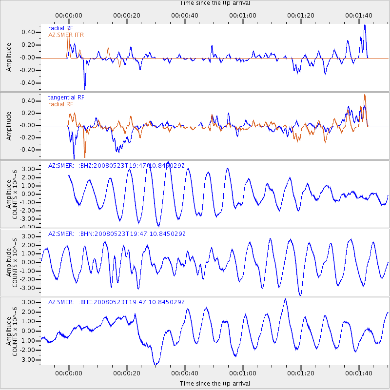
SMER AZ.SMER - Earthquake Result Viewer
*The percent match for this event was below the threshold and hence no stack was calculated.
| Earthquake location: |
Central Mid-Atlantic Ridge |
| Earthquake latitude/longitude: |
7.3/-34.9 |
| Earthquake time(UTC): |
2008/05/23 (144) 19:35:34 GMT |
| Earthquake Depth: |
9.0 km |
| Earthquake Magnitude: |
6.0 MB, 6.4 MS, 6.5 MW, 6.5 MW |
| Earthquake Catalog/Contributor: |
WHDF/NEIC |
|
| Network: |
AZ ANZA Regional Network |
| Station: |
SMER AZ.SMER |
| Lat/Lon: |
33.46 N/117.17 W |
| Elevation: |
355 m |
|
| Distance: |
79.6 deg |
| Az: |
302.617 deg |
| Baz: |
88.104 deg |
| Ray Param: |
$rayparam |
*The percent match for this event was below the threshold and hence was not used in the summary stack. |
|
| Radial Match: |
72.09107 % |
| Radial Bump: |
400 |
| Transverse Match: |
52.146156 % |
| Transverse Bump: |
400 |
| SOD ConfigId: |
2504 |
| Insert Time: |
2010-02-26 20:46:54.330 +0000 |
| GWidth: |
2.5 |
| Max Bumps: |
400 |
| Tol: |
0.001 |
|
Signal To Noise
| Channel | StoN | STA | LTA |
| AZ:SMER: :BHN:20080523T19:47:10.845029Z | 1.4156286 | 1.4934118E-6 | 1.0549461E-6 |
| AZ:SMER: :BHE:20080523T19:47:10.845029Z | 0.74877304 | 5.3915426E-7 | 7.2005025E-7 |
| AZ:SMER: :BHZ:20080523T19:47:10.845029Z | 1.6116506 | 2.7156507E-6 | 1.6850121E-6 |
| Arrivals |
| Ps | |
| PpPs | |
| PsPs/PpSs | |


