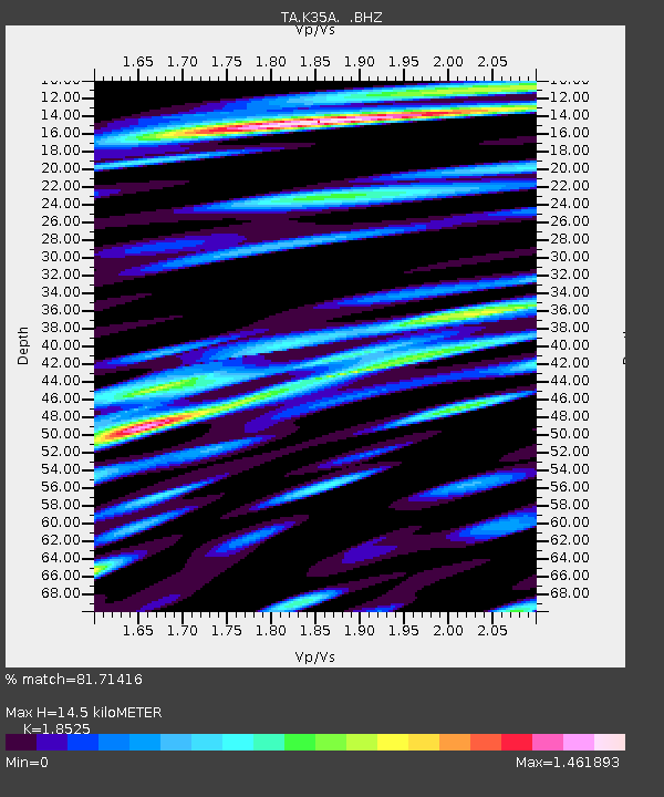
K35A Storm Lake, IA, USA - Earthquake Result Viewer
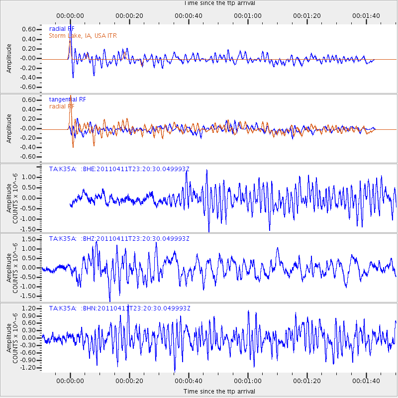
Earthquake location: Near East Coast Of Honshu, Japan
Earthquake latitude/longitude: 35.4/140.6
Earthquake time(UTC): 2011/04/11 (101) 23:08:16 GMT
Earthquake Depth: 15 km
Earthquake Magnitude: 6.0 MB, 6.1 MS, 6.2 MW, 6.2 MW
Earthquake Catalog/Contributor: WHDF/NEIC
Network: TA USArray Transportable Network (new EarthScope stations)
Station: K35A Storm Lake, IA, USA
Lat/Lon: 42.72 N/95.23 W
Elevation: 439 m
Distance: 87.0 deg
Az: 37.616 deg
Baz: 317.428 deg
Ray Param: 0.043607604
Estimated Moho Depth: 14.5 km
Estimated Crust Vp/Vs: 1.85
Assumed Crust Vp: 6.53 km/s
Estimated Crust Vs: 3.525 km/s
Estimated Crust Poisson's Ratio: 0.29
Radial Match: 81.71416 %
Radial Bump: 400
Transverse Match: 69.957664 %
Transverse Bump: 400
SOD ConfigId: 356183
Insert Time: 2011-09-27 10:46:36.969 +0000
GWidth: 2.5
Max Bumps: 400
Tol: 0.001

Signal To Noise

ChannelStoNSTALTA
TA:K35A: :BHZ:20110411T23:20:30.049993Z3.17973544.29759E-71.3515557E-7
TA:K35A: :BHN:20110411T23:20:30.049993Z1.42042221.8782842E-71.3223422E-7
TA:K35A: :BHE:20110411T23:20:30.049993Z1.0677441.8493573E-71.732023E-7
Arrivals
Ps1.9 SECOND
PpPs6.2 SECOND
PsPs/PpSs8.1 SECOND