You are here: Home > Network List > AZ - ANZA Regional Network Stations List
> Station SMER AZ.SMER > Earthquake Result Viewer
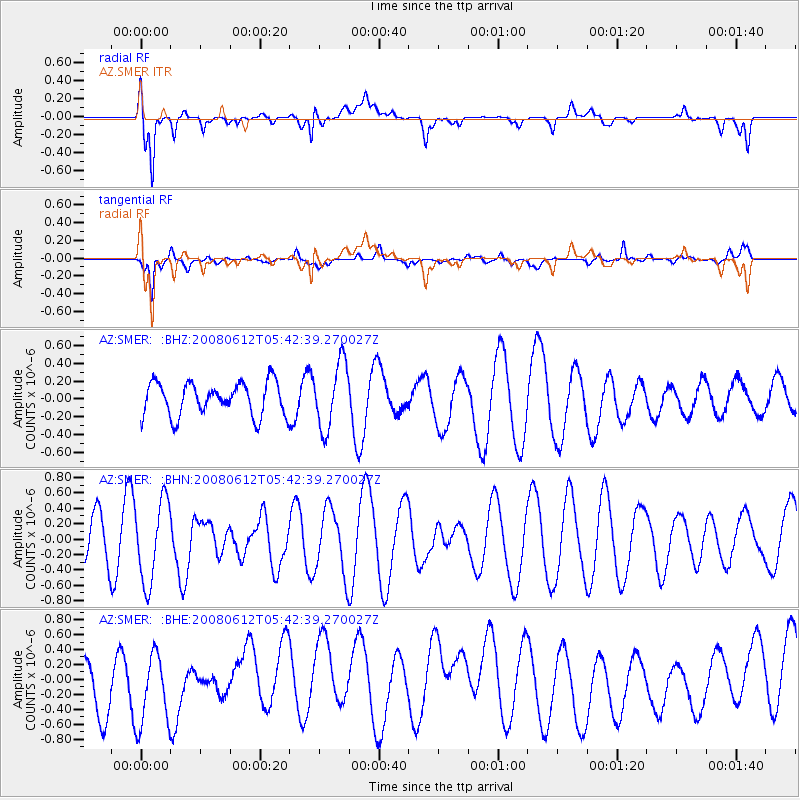
SMER AZ.SMER - Earthquake Result Viewer
*The percent match for this event was below the threshold and hence no stack was calculated.
| Earthquake location: |
Southern East Pacific Rise |
| Earthquake latitude/longitude: |
-50.2/-114.2 |
| Earthquake time(UTC): |
2008/06/12 (164) 05:30:43 GMT |
| Earthquake Depth: |
10 km |
| Earthquake Magnitude: |
5.6 MS, 5.3 MB, 5.9 MW, 5.9 MW |
| Earthquake Catalog/Contributor: |
WHDF/NEIC |
|
| Network: |
AZ ANZA Regional Network |
| Station: |
SMER AZ.SMER |
| Lat/Lon: |
33.46 N/117.17 W |
| Elevation: |
355 m |
|
| Distance: |
83.3 deg |
| Az: |
357.474 deg |
| Baz: |
178.056 deg |
| Ray Param: |
$rayparam |
*The percent match for this event was below the threshold and hence was not used in the summary stack. |
|
| Radial Match: |
74.42207 % |
| Radial Bump: |
400 |
| Transverse Match: |
62.508183 % |
| Transverse Bump: |
397 |
| SOD ConfigId: |
2504 |
| Insert Time: |
2010-02-26 20:46:59.998 +0000 |
| GWidth: |
2.5 |
| Max Bumps: |
400 |
| Tol: |
0.001 |
|
Signal To Noise
| Channel | StoN | STA | LTA |
| AZ:SMER: :BHN:20080612T05:42:39.270027Z | 2.6039503 | 5.258335E-7 | 2.0193686E-7 |
| AZ:SMER: :BHE:20080612T05:42:39.270027Z | 1.6328611 | 4.9664396E-7 | 3.041557E-7 |
| AZ:SMER: :BHZ:20080612T05:42:39.270027Z | 1.9943562 | 3.702203E-7 | 1.85634E-7 |
| Arrivals |
| Ps | |
| PpPs | |
| PsPs/PpSs | |


