You are here: Home > Network List > TA - USArray Transportable Network (new EarthScope stations) Stations List
> Station C34A RKJ Ranch, Bemidji, MN, USA > Earthquake Result Viewer
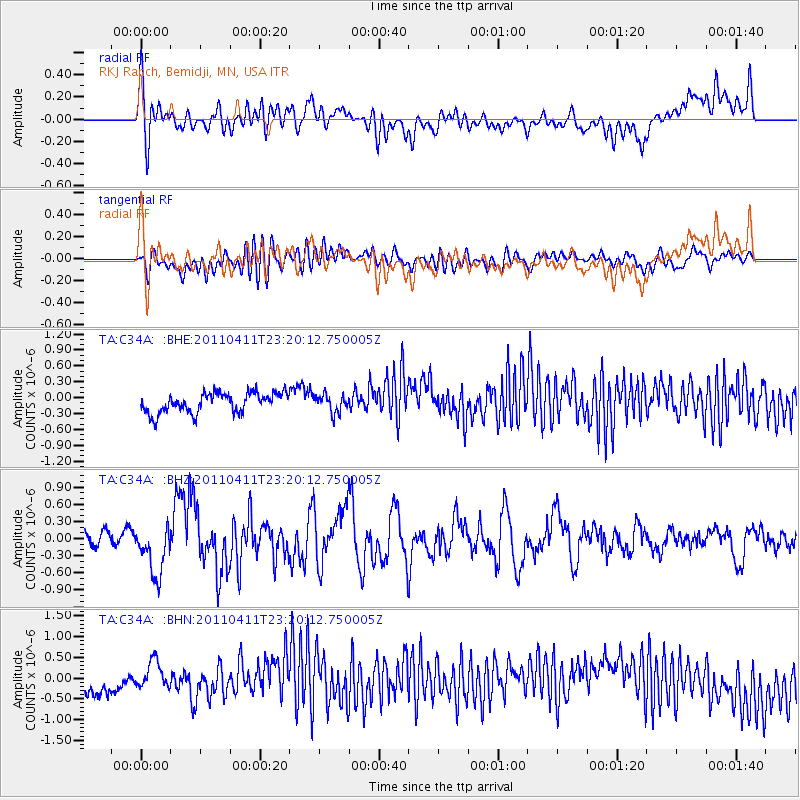
C34A RKJ Ranch, Bemidji, MN, USA - Earthquake Result Viewer
*The percent match for this event was below the threshold and hence no stack was calculated.
| Earthquake location: |
Near East Coast Of Honshu, Japan |
| Earthquake latitude/longitude: |
35.4/140.6 |
| Earthquake time(UTC): |
2011/04/11 (101) 23:08:16 GMT |
| Earthquake Depth: |
15 km |
| Earthquake Magnitude: |
6.0 MB, 6.1 MS, 6.2 MW, 6.2 MW |
| Earthquake Catalog/Contributor: |
WHDF/NEIC |
|
| Network: |
TA USArray Transportable Network (new EarthScope stations) |
| Station: |
C34A RKJ Ranch, Bemidji, MN, USA |
| Lat/Lon: |
47.65 N/94.91 W |
| Elevation: |
441 m |
|
| Distance: |
83.6 deg |
| Az: |
34.101 deg |
| Baz: |
317.367 deg |
| Ray Param: |
$rayparam |
*The percent match for this event was below the threshold and hence was not used in the summary stack. |
|
| Radial Match: |
42.105583 % |
| Radial Bump: |
400 |
| Transverse Match: |
50.79789 % |
| Transverse Bump: |
400 |
| SOD ConfigId: |
356183 |
| Insert Time: |
2011-09-27 11:17:06.542 +0000 |
| GWidth: |
2.5 |
| Max Bumps: |
400 |
| Tol: |
0.001 |
|
Signal To Noise
| Channel | StoN | STA | LTA |
| TA:C34A: :BHZ:20110411T23:20:12.750005Z | 2.7478902 | 4.4123666E-7 | 1.6057288E-7 |
| TA:C34A: :BHN:20110411T23:20:12.750005Z | 0.94525325 | 2.9592917E-7 | 3.1306865E-7 |
| TA:C34A: :BHE:20110411T23:20:12.750005Z | 0.90409654 | 1.6877249E-7 | 1.8667528E-7 |
| Arrivals |
| Ps | |
| PpPs | |
| PsPs/PpSs | |


