You are here: Home > Network List > US - United States National Seismic Network Stations List
> Station AMTX Amarillo, Texas, USA > Earthquake Result Viewer
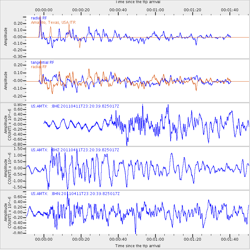
AMTX Amarillo, Texas, USA - Earthquake Result Viewer
*The percent match for this event was below the threshold and hence no stack was calculated.
| Earthquake location: |
Near East Coast Of Honshu, Japan |
| Earthquake latitude/longitude: |
35.4/140.6 |
| Earthquake time(UTC): |
2011/04/11 (101) 23:08:16 GMT |
| Earthquake Depth: |
15 km |
| Earthquake Magnitude: |
6.0 MB, 6.1 MS, 6.2 MW, 6.2 MW |
| Earthquake Catalog/Contributor: |
WHDF/NEIC |
|
| Network: |
US United States National Seismic Network |
| Station: |
AMTX Amarillo, Texas, USA |
| Lat/Lon: |
34.53 N/101.41 W |
| Elevation: |
1010 m |
|
| Distance: |
89.5 deg |
| Az: |
46.792 deg |
| Baz: |
313.855 deg |
| Ray Param: |
$rayparam |
*The percent match for this event was below the threshold and hence was not used in the summary stack. |
|
| Radial Match: |
75.21473 % |
| Radial Bump: |
400 |
| Transverse Match: |
66.86066 % |
| Transverse Bump: |
400 |
| SOD ConfigId: |
356183 |
| Insert Time: |
2011-09-27 11:54:17.789 +0000 |
| GWidth: |
2.5 |
| Max Bumps: |
400 |
| Tol: |
0.001 |
|
Signal To Noise
| Channel | StoN | STA | LTA |
| US:AMTX: :BHZ:20110411T23:20:39.825017Z | 5.0361967 | 7.752009E-7 | 1.5392585E-7 |
| US:AMTX: :BHN:20110411T23:20:39.825017Z | 0.81715465 | 1.17801655E-7 | 1.4416078E-7 |
| US:AMTX: :BHE:20110411T23:20:39.825017Z | 1.5441029 | 1.7794162E-7 | 1.1523949E-7 |
| Arrivals |
| Ps | |
| PpPs | |
| PsPs/PpSs | |


