You are here: Home > Network List > TA - USArray Transportable Network (new EarthScope stations) Stations List
> Station P33A Williams Farm, Concordia, KS, USA > Earthquake Result Viewer
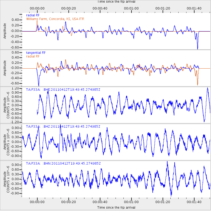
P33A Williams Farm, Concordia, KS, USA - Earthquake Result Viewer
*The percent match for this event was below the threshold and hence no stack was calculated.
| Earthquake location: |
Eastern Honshu, Japan |
| Earthquake latitude/longitude: |
39.4/141.9 |
| Earthquake time(UTC): |
2011/04/12 (102) 19:37:48 GMT |
| Earthquake Depth: |
45 km |
| Earthquake Magnitude: |
5.6 MB, 5.0 MS, 5.6 MW, 5.6 MW |
| Earthquake Catalog/Contributor: |
WHDF/NEIC |
|
| Network: |
TA USArray Transportable Network (new EarthScope stations) |
| Station: |
P33A Williams Farm, Concordia, KS, USA |
| Lat/Lon: |
39.44 N/97.69 W |
| Elevation: |
488 m |
|
| Distance: |
84.5 deg |
| Az: |
42.141 deg |
| Baz: |
317.808 deg |
| Ray Param: |
$rayparam |
*The percent match for this event was below the threshold and hence was not used in the summary stack. |
|
| Radial Match: |
47.41423 % |
| Radial Bump: |
400 |
| Transverse Match: |
62.466553 % |
| Transverse Bump: |
400 |
| SOD ConfigId: |
356183 |
| Insert Time: |
2011-09-27 13:14:55.600 +0000 |
| GWidth: |
2.5 |
| Max Bumps: |
400 |
| Tol: |
0.001 |
|
Signal To Noise
| Channel | StoN | STA | LTA |
| TA:P33A: :BHZ:20110412T19:49:45.274985Z | 1.6476772 | 5.9357154E-7 | 3.6024747E-7 |
| TA:P33A: :BHN:20110412T19:49:45.274985Z | 0.896536 | 3.0628834E-7 | 3.4163529E-7 |
| TA:P33A: :BHE:20110412T19:49:45.274985Z | 0.8987742 | 4.5897198E-7 | 5.106644E-7 |
| Arrivals |
| Ps | |
| PpPs | |
| PsPs/PpSs | |


