You are here: Home > Network List > TA - USArray Transportable Network (new EarthScope stations) Stations List
> Station 635A Leesville, TX, USA > Earthquake Result Viewer
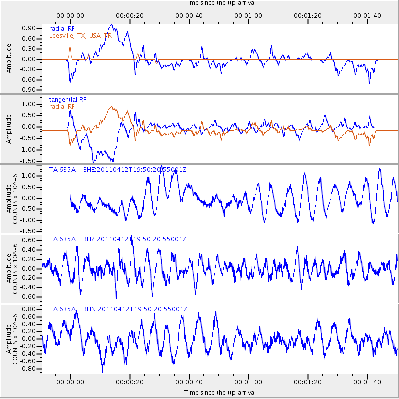
635A Leesville, TX, USA - Earthquake Result Viewer
*The percent match for this event was below the threshold and hence no stack was calculated.
| Earthquake location: |
Eastern Honshu, Japan |
| Earthquake latitude/longitude: |
39.4/141.9 |
| Earthquake time(UTC): |
2011/04/12 (102) 19:37:48 GMT |
| Earthquake Depth: |
45 km |
| Earthquake Magnitude: |
5.6 MB, 5.0 MS, 5.6 MW, 5.6 MW |
| Earthquake Catalog/Contributor: |
WHDF/NEIC |
|
| Network: |
TA USArray Transportable Network (new EarthScope stations) |
| Station: |
635A Leesville, TX, USA |
| Lat/Lon: |
29.39 N/97.77 W |
| Elevation: |
119 m |
|
| Distance: |
91.9 deg |
| Az: |
48.91 deg |
| Baz: |
317.977 deg |
| Ray Param: |
$rayparam |
*The percent match for this event was below the threshold and hence was not used in the summary stack. |
|
| Radial Match: |
55.943325 % |
| Radial Bump: |
400 |
| Transverse Match: |
58.531742 % |
| Transverse Bump: |
400 |
| SOD ConfigId: |
356183 |
| Insert Time: |
2011-09-27 13:17:44.986 +0000 |
| GWidth: |
2.5 |
| Max Bumps: |
400 |
| Tol: |
0.001 |
|
Signal To Noise
| Channel | StoN | STA | LTA |
| TA:635A: :BHZ:20110412T19:50:20.55001Z | 1.4480952 | 2.7705212E-7 | 1.9132177E-7 |
| TA:635A: :BHN:20110412T19:50:20.55001Z | 1.4156249 | 5.0056576E-7 | 3.5360054E-7 |
| TA:635A: :BHE:20110412T19:50:20.55001Z | 4.355229 | 1.144127E-6 | 2.6270195E-7 |
| Arrivals |
| Ps | |
| PpPs | |
| PsPs/PpSs | |


