You are here: Home > Network List > TA - USArray Transportable Network (new EarthScope stations) Stations List
> Station Z37A Pogue Cattle Company, Sulphur Springs, TX, USA > Earthquake Result Viewer
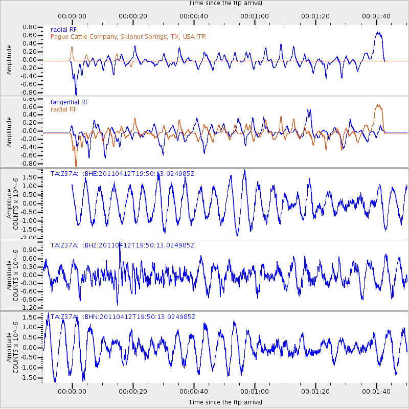
Z37A Pogue Cattle Company, Sulphur Springs, TX, USA - Earthquake Result Viewer
*The percent match for this event was below the threshold and hence no stack was calculated.
| Earthquake location: |
Eastern Honshu, Japan |
| Earthquake latitude/longitude: |
39.4/141.9 |
| Earthquake time(UTC): |
2011/04/12 (102) 19:37:48 GMT |
| Earthquake Depth: |
45 km |
| Earthquake Magnitude: |
5.6 MB, 5.0 MS, 5.6 MW, 5.6 MW |
| Earthquake Catalog/Contributor: |
WHDF/NEIC |
|
| Network: |
TA USArray Transportable Network (new EarthScope stations) |
| Station: |
Z37A Pogue Cattle Company, Sulphur Springs, TX, USA |
| Lat/Lon: |
33.20 N/95.62 W |
| Elevation: |
146 m |
|
| Distance: |
90.3 deg |
| Az: |
45.016 deg |
| Baz: |
319.163 deg |
| Ray Param: |
$rayparam |
*The percent match for this event was below the threshold and hence was not used in the summary stack. |
|
| Radial Match: |
38.389835 % |
| Radial Bump: |
344 |
| Transverse Match: |
43.83006 % |
| Transverse Bump: |
332 |
| SOD ConfigId: |
356183 |
| Insert Time: |
2011-09-27 13:19:21.753 +0000 |
| GWidth: |
2.5 |
| Max Bumps: |
400 |
| Tol: |
0.001 |
|
Signal To Noise
| Channel | StoN | STA | LTA |
| TA:Z37A: :BHZ:20110412T19:50:13.024985Z | 1.3207996 | 3.6744598E-7 | 2.7819962E-7 |
| TA:Z37A: :BHN:20110412T19:50:13.024985Z | 1.4686412 | 1.0240457E-6 | 6.972743E-7 |
| TA:Z37A: :BHE:20110412T19:50:13.024985Z | 1.2016728 | 9.225272E-7 | 7.677025E-7 |
| Arrivals |
| Ps | |
| PpPs | |
| PsPs/PpSs | |


