You are here: Home > Network List > AZ - ANZA Regional Network Stations List
> Station SMER AZ.SMER > Earthquake Result Viewer
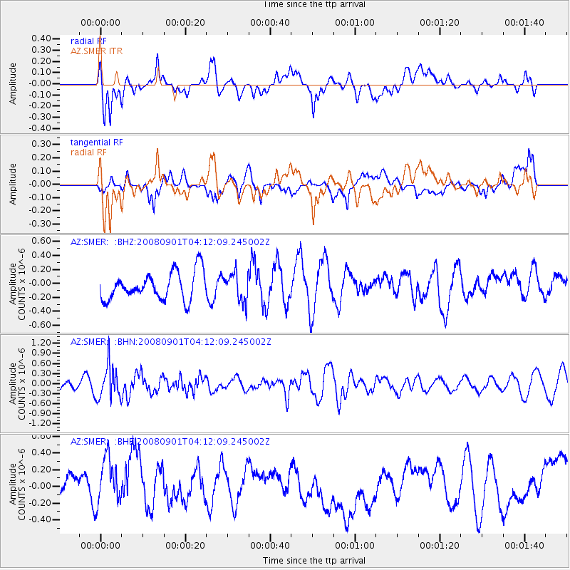
SMER AZ.SMER - Earthquake Result Viewer
*The percent match for this event was below the threshold and hence no stack was calculated.
| Earthquake location: |
South Of Fiji Islands |
| Earthquake latitude/longitude: |
-25.4/-177.6 |
| Earthquake time(UTC): |
2008/09/01 (245) 04:00:39 GMT |
| Earthquake Depth: |
171 km |
| Earthquake Magnitude: |
5.7 MB, 6.0 MW, 6.0 MW |
| Earthquake Catalog/Contributor: |
WHDF/NEIC |
|
| Network: |
AZ ANZA Regional Network |
| Station: |
SMER AZ.SMER |
| Lat/Lon: |
33.46 N/117.17 W |
| Elevation: |
355 m |
|
| Distance: |
82.0 deg |
| Az: |
47.262 deg |
| Baz: |
232.626 deg |
| Ray Param: |
$rayparam |
*The percent match for this event was below the threshold and hence was not used in the summary stack. |
|
| Radial Match: |
45.50919 % |
| Radial Bump: |
400 |
| Transverse Match: |
41.284214 % |
| Transverse Bump: |
400 |
| SOD ConfigId: |
2504 |
| Insert Time: |
2010-02-26 20:47:26.991 +0000 |
| GWidth: |
2.5 |
| Max Bumps: |
400 |
| Tol: |
0.001 |
|
Signal To Noise
| Channel | StoN | STA | LTA |
| AZ:SMER: :BHN:20080901T04:12:09.245002Z | 2.1892698 | 5.0215675E-7 | 2.2937178E-7 |
| AZ:SMER: :BHE:20080901T04:12:09.245002Z | 2.1731353 | 3.420267E-7 | 1.573886E-7 |
| AZ:SMER: :BHZ:20080901T04:12:09.245002Z | 1.0175754 | 2.0130277E-7 | 1.978259E-7 |
| Arrivals |
| Ps | |
| PpPs | |
| PsPs/PpSs | |


