You are here: Home > Network List > TA - USArray Transportable Network (new EarthScope stations) Stations List
> Station 436A Wall Ranch, Gause, TX, USA > Earthquake Result Viewer
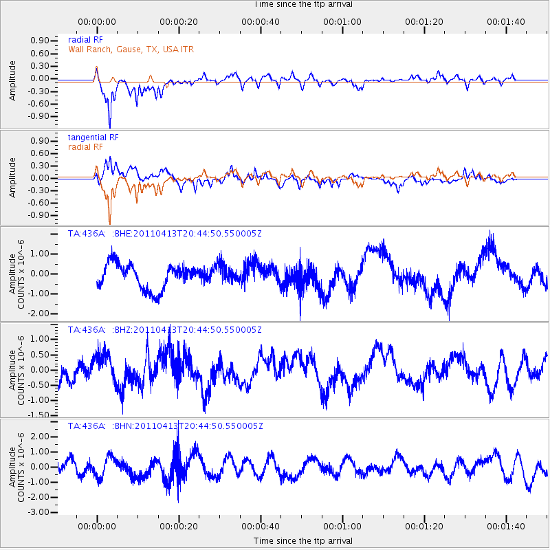
436A Wall Ranch, Gause, TX, USA - Earthquake Result Viewer
*The percent match for this event was below the threshold and hence no stack was calculated.
| Earthquake location: |
Off East Coast Of Honshu, Japan |
| Earthquake latitude/longitude: |
39.6/143.2 |
| Earthquake time(UTC): |
2011/04/13 (103) 20:32:21 GMT |
| Earthquake Depth: |
18 km |
| Earthquake Magnitude: |
5.7 MB, 5.5 MW |
| Earthquake Catalog/Contributor: |
WHDF/NEIC |
|
| Network: |
TA USArray Transportable Network (new EarthScope stations) |
| Station: |
436A Wall Ranch, Gause, TX, USA |
| Lat/Lon: |
30.77 N/96.80 W |
| Elevation: |
109 m |
|
| Distance: |
90.5 deg |
| Az: |
48.189 deg |
| Baz: |
318.021 deg |
| Ray Param: |
$rayparam |
*The percent match for this event was below the threshold and hence was not used in the summary stack. |
|
| Radial Match: |
72.78063 % |
| Radial Bump: |
400 |
| Transverse Match: |
71.52384 % |
| Transverse Bump: |
400 |
| SOD ConfigId: |
356183 |
| Insert Time: |
2011-09-27 14:33:10.060 +0000 |
| GWidth: |
2.5 |
| Max Bumps: |
400 |
| Tol: |
0.001 |
|
Signal To Noise
| Channel | StoN | STA | LTA |
| TA:436A: :BHZ:20110413T20:44:50.550005Z | 1.0169709 | 5.0867624E-7 | 5.0018764E-7 |
| TA:436A: :BHN:20110413T20:44:50.550005Z | 1.8648794 | 6.813226E-7 | 3.6534408E-7 |
| TA:436A: :BHE:20110413T20:44:50.550005Z | 0.7331158 | 4.54554E-7 | 6.200303E-7 |
| Arrivals |
| Ps | |
| PpPs | |
| PsPs/PpSs | |


