You are here: Home > Network List > US - United States National Seismic Network Stations List
> Station WMOK Wichita Mountains, Oklahoma, USA > Earthquake Result Viewer
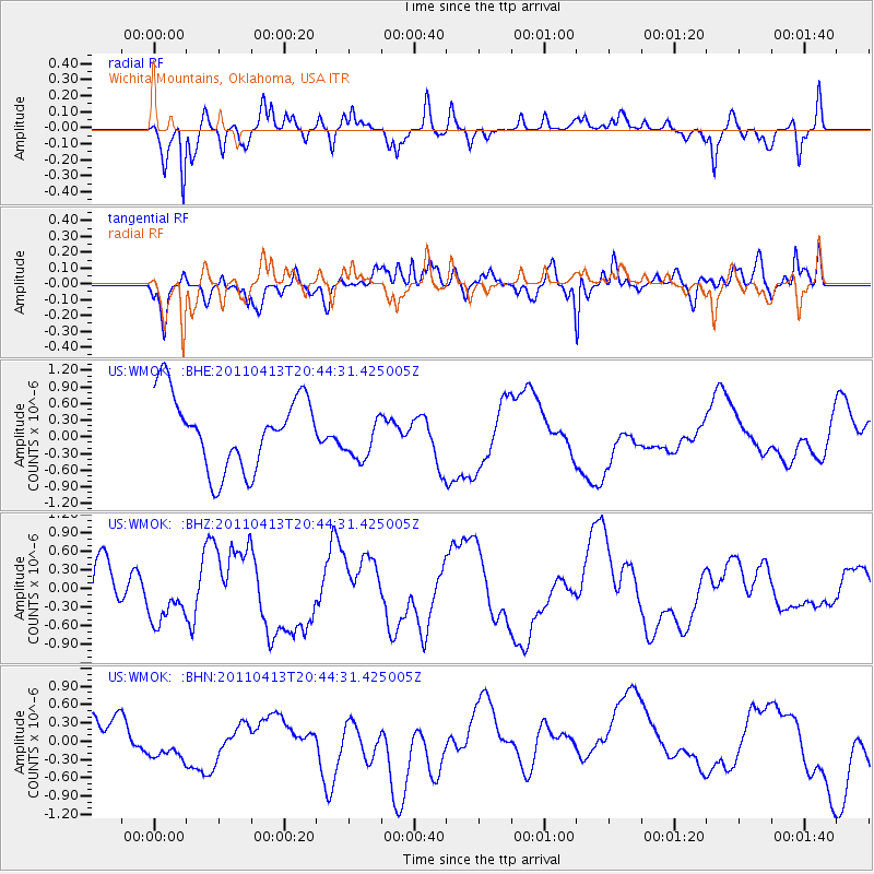
WMOK Wichita Mountains, Oklahoma, USA - Earthquake Result Viewer
*The percent match for this event was below the threshold and hence no stack was calculated.
| Earthquake location: |
Off East Coast Of Honshu, Japan |
| Earthquake latitude/longitude: |
39.6/143.2 |
| Earthquake time(UTC): |
2011/04/13 (103) 20:32:21 GMT |
| Earthquake Depth: |
18 km |
| Earthquake Magnitude: |
5.7 MB, 5.5 MW |
| Earthquake Catalog/Contributor: |
WHDF/NEIC |
|
| Network: |
US United States National Seismic Network |
| Station: |
WMOK Wichita Mountains, Oklahoma, USA |
| Lat/Lon: |
34.74 N/98.78 W |
| Elevation: |
486 m |
|
| Distance: |
86.5 deg |
| Az: |
46.747 deg |
| Baz: |
316.914 deg |
| Ray Param: |
$rayparam |
*The percent match for this event was below the threshold and hence was not used in the summary stack. |
|
| Radial Match: |
59.1904 % |
| Radial Bump: |
400 |
| Transverse Match: |
36.339672 % |
| Transverse Bump: |
400 |
| SOD ConfigId: |
356183 |
| Insert Time: |
2011-09-27 14:42:54.300 +0000 |
| GWidth: |
2.5 |
| Max Bumps: |
400 |
| Tol: |
0.001 |
|
Signal To Noise
| Channel | StoN | STA | LTA |
| US:WMOK: :BHZ:20110413T20:44:31.425005Z | 1.3711828 | 4.2643313E-7 | 3.1099654E-7 |
| US:WMOK: :BHN:20110413T20:44:31.425005Z | 0.9795727 | 3.704352E-7 | 3.7816E-7 |
| US:WMOK: :BHE:20110413T20:44:31.425005Z | 0.6224711 | 4.0594702E-7 | 6.5215403E-7 |
| Arrivals |
| Ps | |
| PpPs | |
| PsPs/PpSs | |


