You are here: Home > Network List > AZ - ANZA Regional Network Stations List
> Station SMER AZ.SMER > Earthquake Result Viewer
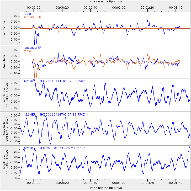
SMER AZ.SMER - Earthquake Result Viewer
*The percent match for this event was below the threshold and hence no stack was calculated.
| Earthquake location: |
South Of Kermadec Islands |
| Earthquake latitude/longitude: |
-33.0/-178.5 |
| Earthquake time(UTC): |
2011/04/14 (104) 05:45:17 GMT |
| Earthquake Depth: |
19 km |
| Earthquake Magnitude: |
5.6 MS, 5.4 MB, 5.4 MW |
| Earthquake Catalog/Contributor: |
WHDF/NEIC |
|
| Network: |
AZ ANZA Regional Network |
| Station: |
SMER AZ.SMER |
| Lat/Lon: |
33.46 N/117.17 W |
| Elevation: |
355 m |
|
| Distance: |
87.8 deg |
| Az: |
47.242 deg |
| Baz: |
227.53 deg |
| Ray Param: |
$rayparam |
*The percent match for this event was below the threshold and hence was not used in the summary stack. |
|
| Radial Match: |
79.35146 % |
| Radial Bump: |
400 |
| Transverse Match: |
38.172504 % |
| Transverse Bump: |
400 |
| SOD ConfigId: |
356183 |
| Insert Time: |
2011-09-27 14:53:33.253 +0000 |
| GWidth: |
2.5 |
| Max Bumps: |
400 |
| Tol: |
0.001 |
|
Signal To Noise
| Channel | StoN | STA | LTA |
| AZ:SMER: :BHZ:20110414T05:57:33.550Z | 2.6827037 | 4.1183378E-7 | 1.5351445E-7 |
| AZ:SMER: :BHN:20110414T05:57:33.550Z | 1.6283311 | 3.6073905E-7 | 2.2153912E-7 |
| AZ:SMER: :BHE:20110414T05:57:33.550Z | 0.97851217 | 1.7836544E-7 | 1.8228228E-7 |
| Arrivals |
| Ps | |
| PpPs | |
| PsPs/PpSs | |


