You are here: Home > Network List > TA - USArray Transportable Network (new EarthScope stations) Stations List
> Station O03D Paynes Creek, CA, USA > Earthquake Result Viewer
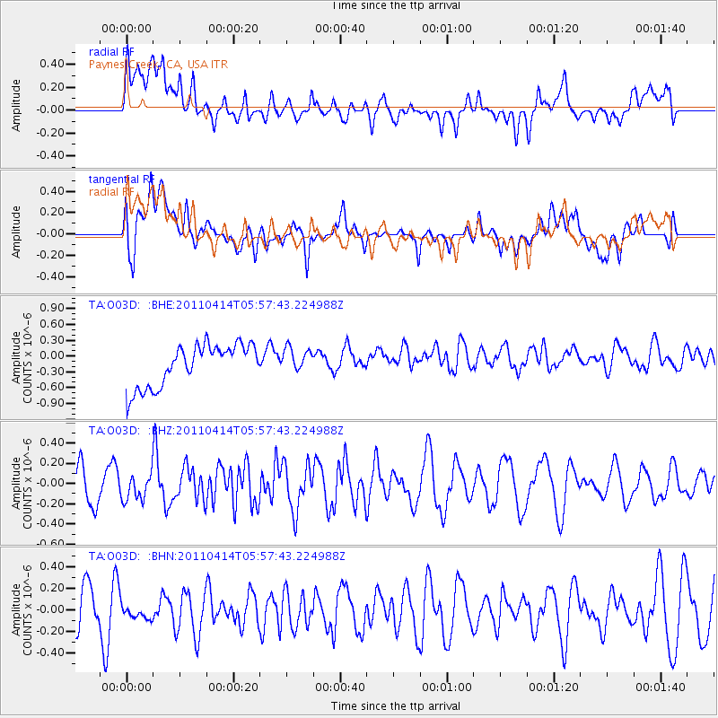
O03D Paynes Creek, CA, USA - Earthquake Result Viewer
*The percent match for this event was below the threshold and hence no stack was calculated.
| Earthquake location: |
South Of Kermadec Islands |
| Earthquake latitude/longitude: |
-33.0/-178.5 |
| Earthquake time(UTC): |
2011/04/14 (104) 05:45:17 GMT |
| Earthquake Depth: |
19 km |
| Earthquake Magnitude: |
5.6 MS, 5.4 MB, 5.4 MW |
| Earthquake Catalog/Contributor: |
WHDF/NEIC |
|
| Network: |
TA USArray Transportable Network (new EarthScope stations) |
| Station: |
O03D Paynes Creek, CA, USA |
| Lat/Lon: |
40.29 N/121.80 W |
| Elevation: |
968 m |
|
| Distance: |
89.8 deg |
| Az: |
39.752 deg |
| Baz: |
224.601 deg |
| Ray Param: |
$rayparam |
*The percent match for this event was below the threshold and hence was not used in the summary stack. |
|
| Radial Match: |
43.47795 % |
| Radial Bump: |
400 |
| Transverse Match: |
42.86125 % |
| Transverse Bump: |
400 |
| SOD ConfigId: |
356183 |
| Insert Time: |
2011-09-27 14:59:10.285 +0000 |
| GWidth: |
2.5 |
| Max Bumps: |
400 |
| Tol: |
0.001 |
|
Signal To Noise
| Channel | StoN | STA | LTA |
| TA:O03D: :BHZ:20110414T05:57:43.224988Z | 0.9060977 | 1.2862974E-7 | 1.4196013E-7 |
| TA:O03D: :BHN:20110414T05:57:43.224988Z | 0.45390084 | 8.171125E-8 | 1.8002004E-7 |
| TA:O03D: :BHE:20110414T05:57:43.224988Z | 0.5966798 | 2.3717477E-7 | 3.9749088E-7 |
| Arrivals |
| Ps | |
| PpPs | |
| PsPs/PpSs | |


