You are here: Home > Network List > AZ - ANZA Regional Network Stations List
> Station SMER AZ.SMER > Earthquake Result Viewer
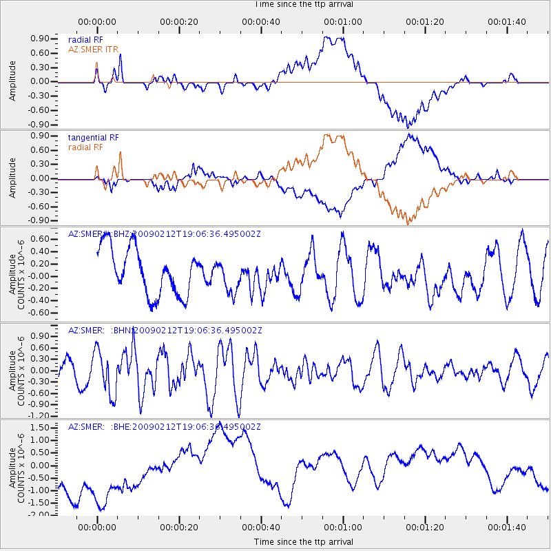
SMER AZ.SMER - Earthquake Result Viewer
*The percent match for this event was below the threshold and hence no stack was calculated.
| Earthquake location: |
Kermadec Islands Region |
| Earthquake latitude/longitude: |
-31.2/-178.1 |
| Earthquake time(UTC): |
2009/02/12 (043) 18:54:28 GMT |
| Earthquake Depth: |
24 km |
| Earthquake Magnitude: |
5.6 MB, 5.6 MS, 5.9 MW, 5.8 MW |
| Earthquake Catalog/Contributor: |
WHDF/NEIC |
|
| Network: |
AZ ANZA Regional Network |
| Station: |
SMER AZ.SMER |
| Lat/Lon: |
33.46 N/117.17 W |
| Elevation: |
355 m |
|
| Distance: |
86.3 deg |
| Az: |
47.078 deg |
| Baz: |
228.621 deg |
| Ray Param: |
$rayparam |
*The percent match for this event was below the threshold and hence was not used in the summary stack. |
|
| Radial Match: |
40.617966 % |
| Radial Bump: |
400 |
| Transverse Match: |
32.423615 % |
| Transverse Bump: |
400 |
| SOD ConfigId: |
2658 |
| Insert Time: |
2010-02-26 20:47:40.391 +0000 |
| GWidth: |
2.5 |
| Max Bumps: |
400 |
| Tol: |
0.001 |
|
Signal To Noise
| Channel | StoN | STA | LTA |
| AZ:SMER: :BHN:20090212T19:06:36.495002Z | 3.1290975 | 5.885209E-7 | 1.8808008E-7 |
| AZ:SMER: :BHE:20090212T19:06:36.495002Z | 1.4922695 | 2.0837783E-6 | 1.396382E-6 |
| AZ:SMER: :BHZ:20090212T19:06:36.495002Z | 0.7141955 | 2.7123926E-7 | 3.7978293E-7 |
| Arrivals |
| Ps | |
| PpPs | |
| PsPs/PpSs | |


