You are here: Home > Network List > TA - USArray Transportable Network (new EarthScope stations) Stations List
> Station E29A Napoleon, ND, USA > Earthquake Result Viewer
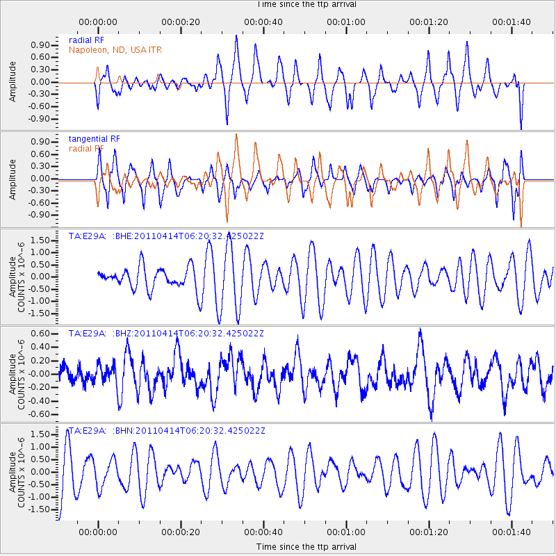
E29A Napoleon, ND, USA - Earthquake Result Viewer
*The percent match for this event was below the threshold and hence no stack was calculated.
| Earthquake location: |
Near East Coast Of Honshu, Japan |
| Earthquake latitude/longitude: |
35.6/141.9 |
| Earthquake time(UTC): |
2011/04/14 (104) 06:08:47 GMT |
| Earthquake Depth: |
10 km |
| Earthquake Magnitude: |
5.5 MS, 5.3 MB, 5.8 MW, 5.7 MW |
| Earthquake Catalog/Contributor: |
WHDF/NEIC |
|
| Network: |
TA USArray Transportable Network (new EarthScope stations) |
| Station: |
E29A Napoleon, ND, USA |
| Lat/Lon: |
46.57 N/99.64 W |
| Elevation: |
628 m |
|
| Distance: |
81.3 deg |
| Az: |
37.841 deg |
| Baz: |
313.531 deg |
| Ray Param: |
$rayparam |
*The percent match for this event was below the threshold and hence was not used in the summary stack. |
|
| Radial Match: |
44.149235 % |
| Radial Bump: |
346 |
| Transverse Match: |
50.035126 % |
| Transverse Bump: |
324 |
| SOD ConfigId: |
356183 |
| Insert Time: |
2011-09-27 15:28:26.803 +0000 |
| GWidth: |
2.5 |
| Max Bumps: |
400 |
| Tol: |
0.001 |
|
Signal To Noise
| Channel | StoN | STA | LTA |
| TA:E29A: :BHZ:20110414T06:20:32.425022Z | 0.9280463 | 1.4720719E-7 | 1.5862052E-7 |
| TA:E29A: :BHN:20110414T06:20:32.425022Z | 0.57482815 | 5.298145E-7 | 9.2169194E-7 |
| TA:E29A: :BHE:20110414T06:20:32.425022Z | 3.0558362 | 1.3516321E-6 | 4.4231172E-7 |
| Arrivals |
| Ps | |
| PpPs | |
| PsPs/PpSs | |


