You are here: Home > Network List > TA - USArray Transportable Network (new EarthScope stations) Stations List
> Station U36A Oologah, OK, USA > Earthquake Result Viewer
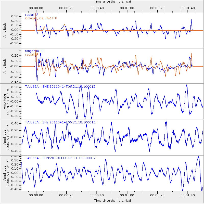
U36A Oologah, OK, USA - Earthquake Result Viewer
*The percent match for this event was below the threshold and hence no stack was calculated.
| Earthquake location: |
Near East Coast Of Honshu, Japan |
| Earthquake latitude/longitude: |
35.6/141.9 |
| Earthquake time(UTC): |
2011/04/14 (104) 06:08:47 GMT |
| Earthquake Depth: |
10 km |
| Earthquake Magnitude: |
5.5 MS, 5.3 MB, 5.8 MW, 5.7 MW |
| Earthquake Catalog/Contributor: |
WHDF/NEIC |
|
| Network: |
TA USArray Transportable Network (new EarthScope stations) |
| Station: |
U36A Oologah, OK, USA |
| Lat/Lon: |
36.39 N/95.73 W |
| Elevation: |
187 m |
|
| Distance: |
90.6 deg |
| Az: |
42.953 deg |
| Baz: |
316.484 deg |
| Ray Param: |
$rayparam |
*The percent match for this event was below the threshold and hence was not used in the summary stack. |
|
| Radial Match: |
45.870495 % |
| Radial Bump: |
400 |
| Transverse Match: |
55.83779 % |
| Transverse Bump: |
400 |
| SOD ConfigId: |
356183 |
| Insert Time: |
2011-09-27 15:33:53.862 +0000 |
| GWidth: |
2.5 |
| Max Bumps: |
400 |
| Tol: |
0.001 |
|
Signal To Noise
| Channel | StoN | STA | LTA |
| TA:U36A: :BHZ:20110414T06:21:18.10001Z | 0.64269936 | 1.0957746E-7 | 1.7049568E-7 |
| TA:U36A: :BHN:20110414T06:21:18.10001Z | 1.1499882 | 1.926066E-7 | 1.6748572E-7 |
| TA:U36A: :BHE:20110414T06:21:18.10001Z | 2.6456134 | 2.4274343E-7 | 9.175317E-8 |
| Arrivals |
| Ps | |
| PpPs | |
| PsPs/PpSs | |


