You are here: Home > Network List > AZ - ANZA Regional Network Stations List
> Station LVA2 AZ.LVA2 > Earthquake Result Viewer
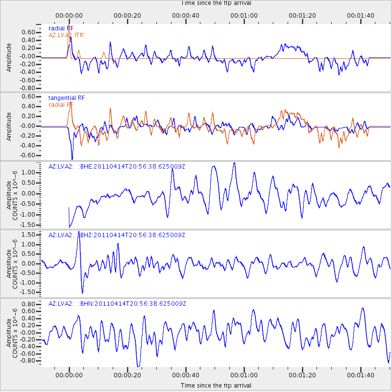
LVA2 AZ.LVA2 - Earthquake Result Viewer
*The percent match for this event was below the threshold and hence no stack was calculated.
| Earthquake location: |
Near Coast Of Nicaragua |
| Earthquake latitude/longitude: |
11.2/-86.4 |
| Earthquake time(UTC): |
2011/04/14 (104) 20:50:16 GMT |
| Earthquake Depth: |
35 km |
| Earthquake Magnitude: |
5.6 MB, 5.4 MS, 5.7 MW, 5.6 MW |
| Earthquake Catalog/Contributor: |
WHDF/NEIC |
|
| Network: |
AZ ANZA Regional Network |
| Station: |
LVA2 AZ.LVA2 |
| Lat/Lon: |
33.35 N/116.56 W |
| Elevation: |
1435 m |
|
| Distance: |
35.4 deg |
| Az: |
313.361 deg |
| Baz: |
121.529 deg |
| Ray Param: |
$rayparam |
*The percent match for this event was below the threshold and hence was not used in the summary stack. |
|
| Radial Match: |
48.75001 % |
| Radial Bump: |
400 |
| Transverse Match: |
71.26801 % |
| Transverse Bump: |
400 |
| SOD ConfigId: |
356183 |
| Insert Time: |
2011-09-27 15:52:16.415 +0000 |
| GWidth: |
2.5 |
| Max Bumps: |
400 |
| Tol: |
0.001 |
|
Signal To Noise
| Channel | StoN | STA | LTA |
| AZ:LVA2: :BHZ:20110414T20:56:38.625009Z | 4.5357976 | 8.0157696E-7 | 1.767224E-7 |
| AZ:LVA2: :BHN:20110414T20:56:38.625009Z | 0.84868026 | 3.5726927E-7 | 4.209704E-7 |
| AZ:LVA2: :BHE:20110414T20:56:38.625009Z | 0.8384501 | 3.5655137E-7 | 4.2525056E-7 |
| Arrivals |
| Ps | |
| PpPs | |
| PsPs/PpSs | |


