You are here: Home > Network List > AZ - ANZA Regional Network Stations List
> Station SMER AZ.SMER > Earthquake Result Viewer
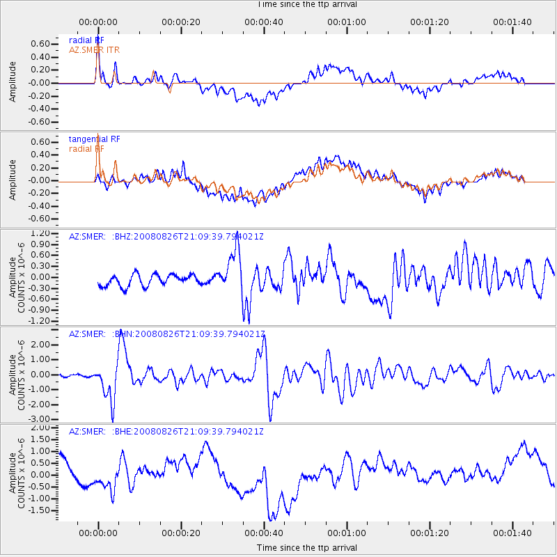
SMER AZ.SMER - Earthquake Result Viewer
*The percent match for this event was below the threshold and hence no stack was calculated.
| Earthquake location: |
Peru-Brazil Border Region |
| Earthquake latitude/longitude: |
-7.6/-74.4 |
| Earthquake time(UTC): |
2008/08/26 (239) 21:00:36 GMT |
| Earthquake Depth: |
154 km |
| Earthquake Magnitude: |
6.0 MB, 6.4 MW, 6.4 MW |
| Earthquake Catalog/Contributor: |
WHDF/NEIC |
|
| Network: |
AZ ANZA Regional Network |
| Station: |
SMER AZ.SMER |
| Lat/Lon: |
33.46 N/117.17 W |
| Elevation: |
355 m |
|
| Distance: |
57.6 deg |
| Az: |
317.737 deg |
| Baz: |
127.115 deg |
| Ray Param: |
$rayparam |
*The percent match for this event was below the threshold and hence was not used in the summary stack. |
|
| Radial Match: |
63.745106 % |
| Radial Bump: |
400 |
| Transverse Match: |
43.20895 % |
| Transverse Bump: |
400 |
| SOD ConfigId: |
2504 |
| Insert Time: |
2010-02-26 20:47:53.499 +0000 |
| GWidth: |
2.5 |
| Max Bumps: |
400 |
| Tol: |
0.001 |
|
Signal To Noise
| Channel | StoN | STA | LTA |
| AZ:SMER: :BHN:20080826T21:09:39.794021Z | 10.797894 | 1.2752868E-6 | 1.1810514E-7 |
| AZ:SMER: :BHE:20080826T21:09:39.794021Z | 0.3040329 | 3.3212723E-7 | 1.0924056E-6 |
| AZ:SMER: :BHZ:20080826T21:09:39.794021Z | 3.9082189 | 6.118804E-7 | 1.5656246E-7 |
| Arrivals |
| Ps | |
| PpPs | |
| PsPs/PpSs | |


