You are here: Home > Network List > AZ - ANZA Regional Network Stations List
> Station SMER AZ.SMER > Earthquake Result Viewer
SMER AZ.SMER - Earthquake Result Viewer
*The percent match for this event was below the threshold and hence no stack was calculated.
| Earthquake location: |
Loyalty Islands |
| Earthquake latitude/longitude: |
-20.2/168.9 |
| Earthquake time(UTC): |
2008/04/09 (100) 11:13:17 GMT |
| Earthquake Depth: |
13 km |
| Earthquake Magnitude: |
5.6 MB, 6.3 MS, 6.4 MW, 6.3 MW |
| Earthquake Catalog/Contributor: |
WHDF/NEIC |
|
| Network: |
AZ ANZA Regional Network |
| Station: |
SMER AZ.SMER |
| Lat/Lon: |
33.46 N/117.17 W |
| Elevation: |
355 m |
|
| Distance: |
88.4 deg |
| Az: |
53.495 deg |
| Baz: |
244.586 deg |
| Ray Param: |
$rayparam |
*The percent match for this event was below the threshold and hence was not used in the summary stack. |
|
| Radial Match: |
53.90955 % |
| Radial Bump: |
387 |
| Transverse Match: |
66.755646 % |
| Transverse Bump: |
400 |
| SOD ConfigId: |
2504 |
| Insert Time: |
2010-02-26 20:47:55.529 +0000 |
| GWidth: |
2.5 |
| Max Bumps: |
400 |
| Tol: |
0.001 |
|
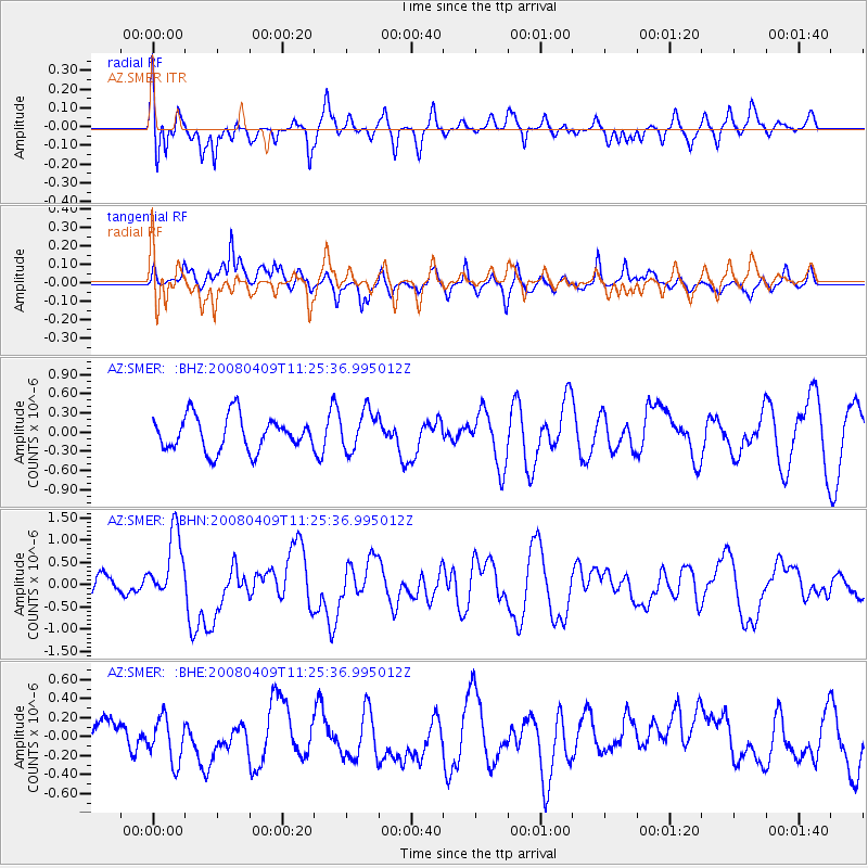
Signal To Noise
| Channel | StoN | STA | LTA |
| AZ:SMER: :BHN:20080409T11:25:36.995012Z | 3.509658 | 7.720881E-7 | 2.1998954E-7 |
| AZ:SMER: :BHE:20080409T11:25:36.995012Z | 1.1490421 | 2.5032043E-7 | 2.1785141E-7 |
| AZ:SMER: :BHZ:20080409T11:25:36.995012Z | 1.1531036 | 3.0821488E-7 | 2.6729157E-7 |
| Arrivals |
| Ps | |
| PpPs | |
| PsPs/PpSs | |


