You are here: Home > Network List > CN - Canadian National Seismograph Network Stations List
> Station INK INUVIK, NT, CANADA.ANADA > Earthquake Result Viewer
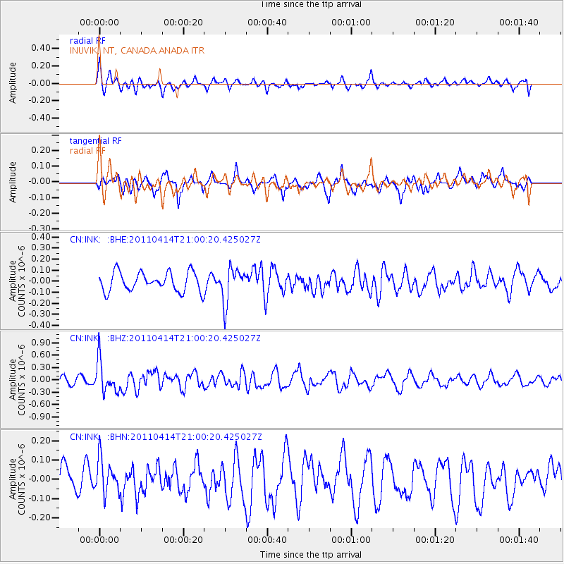
INK INUVIK, NT, CANADA.ANADA - Earthquake Result Viewer
*The percent match for this event was below the threshold and hence no stack was calculated.
| Earthquake location: |
Near Coast Of Nicaragua |
| Earthquake latitude/longitude: |
11.2/-86.4 |
| Earthquake time(UTC): |
2011/04/14 (104) 20:50:16 GMT |
| Earthquake Depth: |
35 km |
| Earthquake Magnitude: |
5.6 MB, 5.4 MS, 5.7 MW, 5.6 MW |
| Earthquake Catalog/Contributor: |
WHDF/NEIC |
|
| Network: |
CN Canadian National Seismograph Network |
| Station: |
INK INUVIK, NT, CANADA.ANADA |
| Lat/Lon: |
68.31 N/133.52 W |
| Elevation: |
40 m |
|
| Distance: |
64.7 deg |
| Az: |
342.454 deg |
| Baz: |
127.276 deg |
| Ray Param: |
$rayparam |
*The percent match for this event was below the threshold and hence was not used in the summary stack. |
|
| Radial Match: |
53.152325 % |
| Radial Bump: |
400 |
| Transverse Match: |
45.598957 % |
| Transverse Bump: |
368 |
| SOD ConfigId: |
356183 |
| Insert Time: |
2011-09-27 16:08:32.858 +0000 |
| GWidth: |
2.5 |
| Max Bumps: |
400 |
| Tol: |
0.001 |
|
Signal To Noise
| Channel | StoN | STA | LTA |
| CN:INK: :BHZ:20110414T21:00:20.425027Z | 3.6602125 | 3.9647935E-7 | 1.083214E-7 |
| CN:INK: :BHN:20110414T21:00:20.425027Z | 1.0328692 | 9.1582336E-8 | 8.8667896E-8 |
| CN:INK: :BHE:20110414T21:00:20.425027Z | 1.871723 | 1.6169842E-7 | 8.639014E-8 |
| Arrivals |
| Ps | |
| PpPs | |
| PsPs/PpSs | |


