You are here: Home > Network List > NE - New England Seismic Network Stations List
> Station EMMW Machias, ME > Earthquake Result Viewer
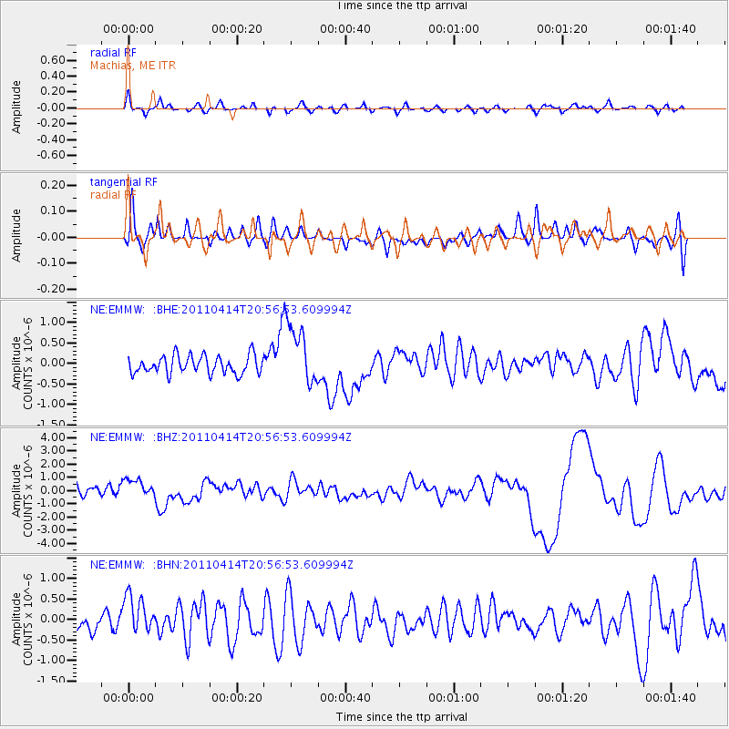
EMMW Machias, ME - Earthquake Result Viewer
*The percent match for this event was below the threshold and hence no stack was calculated.
| Earthquake location: |
Near Coast Of Nicaragua |
| Earthquake latitude/longitude: |
11.2/-86.4 |
| Earthquake time(UTC): |
2011/04/14 (104) 20:50:16 GMT |
| Earthquake Depth: |
35 km |
| Earthquake Magnitude: |
5.6 MB, 5.4 MS, 5.7 MW, 5.6 MW |
| Earthquake Catalog/Contributor: |
WHDF/NEIC |
|
| Network: |
NE New England Seismic Network |
| Station: |
EMMW Machias, ME |
| Lat/Lon: |
44.71 N/67.46 W |
| Elevation: |
34 m |
|
| Distance: |
37.2 deg |
| Az: |
22.474 deg |
| Baz: |
211.741 deg |
| Ray Param: |
$rayparam |
*The percent match for this event was below the threshold and hence was not used in the summary stack. |
|
| Radial Match: |
52.91277 % |
| Radial Bump: |
400 |
| Transverse Match: |
42.54264 % |
| Transverse Bump: |
400 |
| SOD ConfigId: |
356183 |
| Insert Time: |
2011-09-27 16:24:19.214 +0000 |
| GWidth: |
2.5 |
| Max Bumps: |
400 |
| Tol: |
0.001 |
|
Signal To Noise
| Channel | StoN | STA | LTA |
| NE:EMMW: :BHZ:20110414T20:56:53.609994Z | 1.4712669 | 7.4881115E-7 | 5.089567E-7 |
| NE:EMMW: :BHN:20110414T20:56:53.609994Z | 2.1137235 | 4.8869407E-7 | 2.3120056E-7 |
| NE:EMMW: :BHE:20110414T20:56:53.609994Z | 3.326047 | 7.2153034E-7 | 2.169333E-7 |
| Arrivals |
| Ps | |
| PpPs | |
| PsPs/PpSs | |


