You are here: Home > Network List > TA - USArray Transportable Network (new EarthScope stations) Stations List
> Station R11A Troy Canyon, Currant, NV, USA > Earthquake Result Viewer
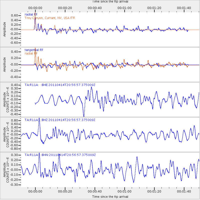
R11A Troy Canyon, Currant, NV, USA - Earthquake Result Viewer
*The percent match for this event was below the threshold and hence no stack was calculated.
| Earthquake location: |
Near Coast Of Nicaragua |
| Earthquake latitude/longitude: |
11.2/-86.4 |
| Earthquake time(UTC): |
2011/04/14 (104) 20:50:16 GMT |
| Earthquake Depth: |
35 km |
| Earthquake Magnitude: |
5.6 MB, 5.4 MS, 5.7 MW, 5.6 MW |
| Earthquake Catalog/Contributor: |
WHDF/NEIC |
|
| Network: |
TA USArray Transportable Network (new EarthScope stations) |
| Station: |
R11A Troy Canyon, Currant, NV, USA |
| Lat/Lon: |
38.35 N/115.59 W |
| Elevation: |
1756 m |
|
| Distance: |
37.6 deg |
| Az: |
321.003 deg |
| Baz: |
128.246 deg |
| Ray Param: |
$rayparam |
*The percent match for this event was below the threshold and hence was not used in the summary stack. |
|
| Radial Match: |
63.161156 % |
| Radial Bump: |
325 |
| Transverse Match: |
56.420982 % |
| Transverse Bump: |
383 |
| SOD ConfigId: |
356183 |
| Insert Time: |
2011-09-27 16:27:32.995 +0000 |
| GWidth: |
2.5 |
| Max Bumps: |
400 |
| Tol: |
0.001 |
|
Signal To Noise
| Channel | StoN | STA | LTA |
| TA:R11A: :BHZ:20110414T20:56:57.375009Z | 4.960964 | 3.704382E-7 | 7.46706E-8 |
| TA:R11A: :BHN:20110414T20:56:57.375009Z | 1.4878975 | 1.4125104E-7 | 9.493331E-8 |
| TA:R11A: :BHE:20110414T20:56:57.375009Z | 2.2509973 | 1.8589476E-7 | 8.2583284E-8 |
| Arrivals |
| Ps | |
| PpPs | |
| PsPs/PpSs | |


