You are here: Home > Network List > TA - USArray Transportable Network (new EarthScope stations) Stations List
> Station H25A Fruitdale, SD, USA > Earthquake Result Viewer
H25A Fruitdale, SD, USA - Earthquake Result Viewer
| Earthquake location: |
Near Coast Of Nicaragua |
| Earthquake latitude/longitude: |
11.2/-86.4 |
| Earthquake time(UTC): |
2011/04/14 (104) 20:50:16 GMT |
| Earthquake Depth: |
35 km |
| Earthquake Magnitude: |
5.6 MB, 5.4 MS, 5.7 MW, 5.6 MW |
| Earthquake Catalog/Contributor: |
WHDF/NEIC |
|
| Network: |
TA USArray Transportable Network (new EarthScope stations) |
| Station: |
H25A Fruitdale, SD, USA |
| Lat/Lon: |
44.62 N/103.60 W |
| Elevation: |
942 m |
|
| Distance: |
36.5 deg |
| Az: |
339.141 deg |
| Baz: |
150.707 deg |
| Ray Param: |
0.07658804 |
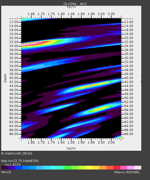
| Estimated Moho Depth: |
22.75 km |
| Estimated Crust Vp/Vs: |
1.64 |
| Assumed Crust Vp: |
6.242 km/s |
| Estimated Crust Vs: |
3.812 km/s |
| Estimated Crust Poisson's Ratio: |
0.20 |
|
| Radial Match: |
80.39163 % |
| Radial Bump: |
366 |
| Transverse Match: |
77.52274 % |
| Transverse Bump: |
377 |
| SOD ConfigId: |
356183 |
| Insert Time: |
2011-09-27 16:32:47.915 +0000 |
| GWidth: |
2.5 |
| Max Bumps: |
400 |
| Tol: |
0.001 |
|
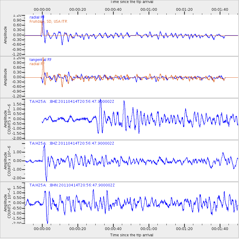
Signal To Noise
| Channel | StoN | STA | LTA |
| TA:H25A: :BHZ:20110414T20:56:47.900002Z | 10.912853 | 1.0230353E-6 | 9.374592E-8 |
| TA:H25A: :BHN:20110414T20:56:47.900002Z | 5.3175206 | 8.8520386E-7 | 1.6646929E-7 |
| TA:H25A: :BHE:20110414T20:56:47.900002Z | 6.502067 | 9.757131E-7 | 1.5006198E-7 |
| Arrivals |
| Ps | 2.5 SECOND |
| PpPs | 8.9 SECOND |
| PsPs/PpSs | 11 SECOND |


