You are here: Home > Network List > AZ - ANZA Regional Network Stations List
> Station SMER AZ.SMER > Earthquake Result Viewer
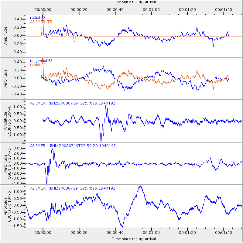
SMER AZ.SMER - Earthquake Result Viewer
*The percent match for this event was below the threshold and hence no stack was calculated.
| Earthquake location: |
Fiji Islands Region |
| Earthquake latitude/longitude: |
-17.3/-177.3 |
| Earthquake time(UTC): |
2008/07/19 (201) 22:39:52 GMT |
| Earthquake Depth: |
391 km |
| Earthquake Magnitude: |
5.9 MB, 6.4 MW, 6.4 MW |
| Earthquake Catalog/Contributor: |
WHDF/NEIC |
|
| Network: |
AZ ANZA Regional Network |
| Station: |
SMER AZ.SMER |
| Lat/Lon: |
33.46 N/117.17 W |
| Elevation: |
355 m |
|
| Distance: |
76.4 deg |
| Az: |
48.237 deg |
| Baz: |
238.453 deg |
| Ray Param: |
$rayparam |
*The percent match for this event was below the threshold and hence was not used in the summary stack. |
|
| Radial Match: |
59.087154 % |
| Radial Bump: |
400 |
| Transverse Match: |
48.23513 % |
| Transverse Bump: |
400 |
| SOD ConfigId: |
2504 |
| Insert Time: |
2010-02-26 20:48:05.801 +0000 |
| GWidth: |
2.5 |
| Max Bumps: |
400 |
| Tol: |
0.001 |
|
Signal To Noise
| Channel | StoN | STA | LTA |
| AZ:SMER: :BHN:20080719T22:50:29.194019Z | 11.394441 | 1.6408895E-6 | 1.440079E-7 |
| AZ:SMER: :BHE:20080719T22:50:29.194019Z | 1.5042436 | 1.046718E-6 | 6.958434E-7 |
| AZ:SMER: :BHZ:20080719T22:50:29.194019Z | 4.1842084 | 6.806017E-7 | 1.626596E-7 |
| Arrivals |
| Ps | |
| PpPs | |
| PsPs/PpSs | |


