You are here: Home > Network List > TA - USArray Transportable Network (new EarthScope stations) Stations List
> Station L31A Butterfield Farm, Chambers, NE, USA > Earthquake Result Viewer
L31A Butterfield Farm, Chambers, NE, USA - Earthquake Result Viewer
| Earthquake location: |
Near Coast Of Nicaragua |
| Earthquake latitude/longitude: |
11.2/-86.4 |
| Earthquake time(UTC): |
2011/04/14 (104) 20:50:16 GMT |
| Earthquake Depth: |
35 km |
| Earthquake Magnitude: |
5.6 MB, 5.4 MS, 5.7 MW, 5.6 MW |
| Earthquake Catalog/Contributor: |
WHDF/NEIC |
|
| Network: |
TA USArray Transportable Network (new EarthScope stations) |
| Station: |
L31A Butterfield Farm, Chambers, NE, USA |
| Lat/Lon: |
42.18 N/98.84 W |
| Elevation: |
670 m |
|
| Distance: |
32.8 deg |
| Az: |
342.722 deg |
| Baz: |
156.916 deg |
| Ray Param: |
0.07846064 |
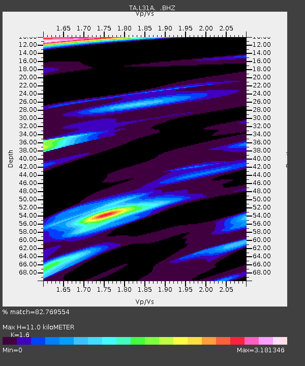
| Estimated Moho Depth: |
11.0 km |
| Estimated Crust Vp/Vs: |
1.60 |
| Assumed Crust Vp: |
6.53 km/s |
| Estimated Crust Vs: |
4.082 km/s |
| Estimated Crust Poisson's Ratio: |
0.18 |
|
| Radial Match: |
82.769554 % |
| Radial Bump: |
362 |
| Transverse Match: |
56.006325 % |
| Transverse Bump: |
366 |
| SOD ConfigId: |
356183 |
| Insert Time: |
2011-09-27 16:44:12.807 +0000 |
| GWidth: |
2.5 |
| Max Bumps: |
400 |
| Tol: |
0.001 |
|

Signal To Noise
| Channel | StoN | STA | LTA |
| TA:L31A: :BHZ:20110414T20:56:15.799996Z | 10.552277 | 1.5100992E-6 | 1.4310649E-7 |
| TA:L31A: :BHN:20110414T20:56:15.799996Z | 5.0314717 | 1.297877E-6 | 2.5795177E-7 |
| TA:L31A: :BHE:20110414T20:56:15.799996Z | 1.8854479 | 7.4493374E-7 | 3.9509644E-7 |
| Arrivals |
| Ps | 1.1 SECOND |
| PpPs | 4.0 SECOND |
| PsPs/PpSs | 5.1 SECOND |


