You are here: Home > Network List > TA - USArray Transportable Network (new EarthScope stations) Stations List
> Station I29A Vivian, Onida, SD, USA > Earthquake Result Viewer
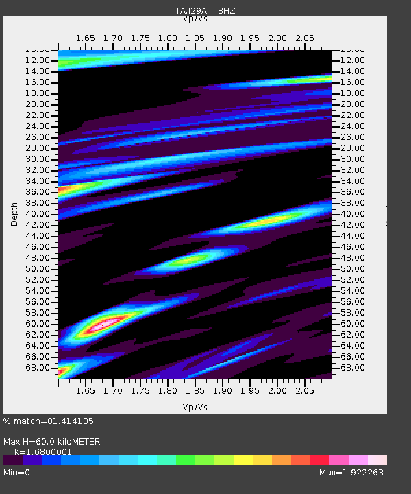
I29A Vivian, Onida, SD, USA - Earthquake Result Viewer
| Earthquake location: |
Near Coast Of Nicaragua |
| Earthquake latitude/longitude: |
11.2/-86.4 |
| Earthquake time(UTC): |
2011/04/14 (104) 20:50:16 GMT |
| Earthquake Depth: |
35 km |
| Earthquake Magnitude: |
5.6 MB, 5.4 MS, 5.7 MW, 5.6 MW |
| Earthquake Catalog/Contributor: |
WHDF/NEIC |
|
| Network: |
TA USArray Transportable Network (new EarthScope stations) |
| Station: |
I29A Vivian, Onida, SD, USA |
| Lat/Lon: |
44.02 N/100.30 W |
| Elevation: |
592 m |
|
| Distance: |
34.9 deg |
| Az: |
342.293 deg |
| Baz: |
155.562 deg |
| Ray Param: |
0.07744818 |
| Estimated Moho Depth: |
60.0 km |
| Estimated Crust Vp/Vs: |
1.68 |
| Assumed Crust Vp: |
6.53 km/s |
| Estimated Crust Vs: |
3.887 km/s |
| Estimated Crust Poisson's Ratio: |
0.23 |
|
| Radial Match: |
81.414185 % |
| Radial Bump: |
349 |
| Transverse Match: |
71.079704 % |
| Transverse Bump: |
400 |
| SOD ConfigId: |
356183 |
| Insert Time: |
2011-09-27 16:45:28.116 +0000 |
| GWidth: |
2.5 |
| Max Bumps: |
400 |
| Tol: |
0.001 |
|

Signal To Noise
| Channel | StoN | STA | LTA |
| TA:I29A: :BHZ:20110414T20:56:34.174996Z | 12.321756 | 1.5787838E-6 | 1.2812977E-7 |
| TA:I29A: :BHN:20110414T20:56:34.174996Z | 4.725577 | 1.407698E-6 | 2.9788913E-7 |
| TA:I29A: :BHE:20110414T20:56:34.174996Z | 4.5361457 | 9.4186055E-7 | 2.0763454E-7 |
| Arrivals |
| Ps | 6.8 SECOND |
| PpPs | 23 SECOND |
| PsPs/PpSs | 29 SECOND |


