You are here: Home > Network List > TA - USArray Transportable Network (new EarthScope stations) Stations List
> Station P32A Huiting Farm, Downs, KS, USA > Earthquake Result Viewer
P32A Huiting Farm, Downs, KS, USA - Earthquake Result Viewer
| Earthquake location: |
Near Coast Of Nicaragua |
| Earthquake latitude/longitude: |
11.2/-86.4 |
| Earthquake time(UTC): |
2011/04/14 (104) 20:50:16 GMT |
| Earthquake Depth: |
35 km |
| Earthquake Magnitude: |
5.6 MB, 5.4 MS, 5.7 MW, 5.6 MW |
| Earthquake Catalog/Contributor: |
WHDF/NEIC |
|
| Network: |
TA USArray Transportable Network (new EarthScope stations) |
| Station: |
P32A Huiting Farm, Downs, KS, USA |
| Lat/Lon: |
39.62 N/98.60 W |
| Elevation: |
524 m |
|
| Distance: |
30.4 deg |
| Az: |
341.077 deg |
| Baz: |
155.669 deg |
| Ray Param: |
0.079320855 |
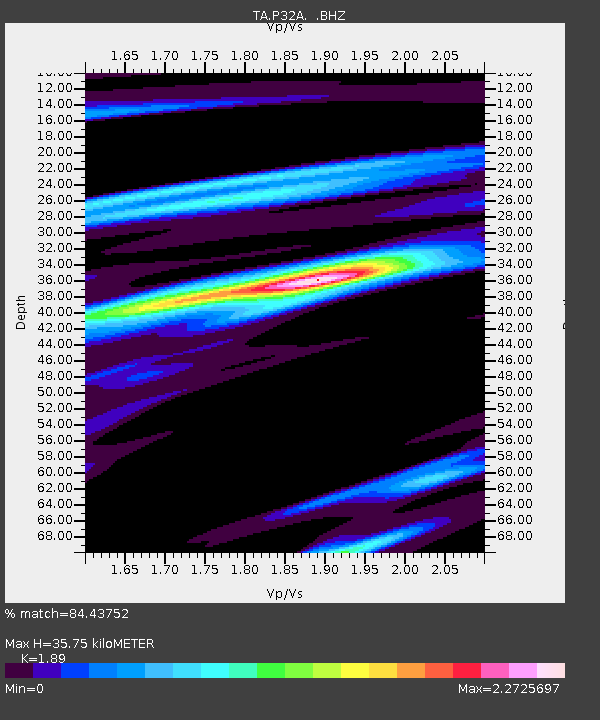
| Estimated Moho Depth: |
35.75 km |
| Estimated Crust Vp/Vs: |
1.89 |
| Assumed Crust Vp: |
6.483 km/s |
| Estimated Crust Vs: |
3.43 km/s |
| Estimated Crust Poisson's Ratio: |
0.31 |
|
| Radial Match: |
84.43752 % |
| Radial Bump: |
322 |
| Transverse Match: |
56.921337 % |
| Transverse Bump: |
400 |
| SOD ConfigId: |
356183 |
| Insert Time: |
2011-09-27 16:47:44.210 +0000 |
| GWidth: |
2.5 |
| Max Bumps: |
400 |
| Tol: |
0.001 |
|
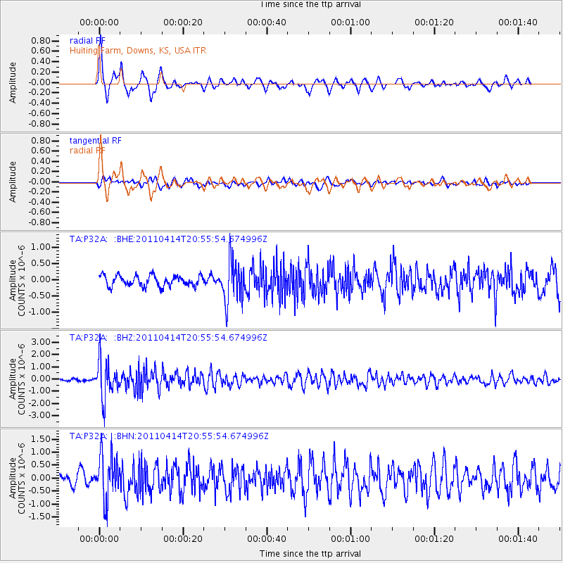
Signal To Noise
| Channel | StoN | STA | LTA |
| TA:P32A: :BHZ:20110414T20:55:54.674996Z | 16.979162 | 1.5279195E-6 | 8.9987914E-8 |
| TA:P32A: :BHN:20110414T20:55:54.674996Z | 5.687495 | 8.7656787E-7 | 1.5412195E-7 |
| TA:P32A: :BHE:20110414T20:55:54.674996Z | 3.9630249 | 6.4736344E-7 | 1.6335085E-7 |
| Arrivals |
| Ps | 5.3 SECOND |
| PpPs | 15 SECOND |
| PsPs/PpSs | 20 SECOND |


