You are here: Home > Network List > TA - USArray Transportable Network (new EarthScope stations) Stations List
> Station L02D Cave Junction, OR, USA > Earthquake Result Viewer
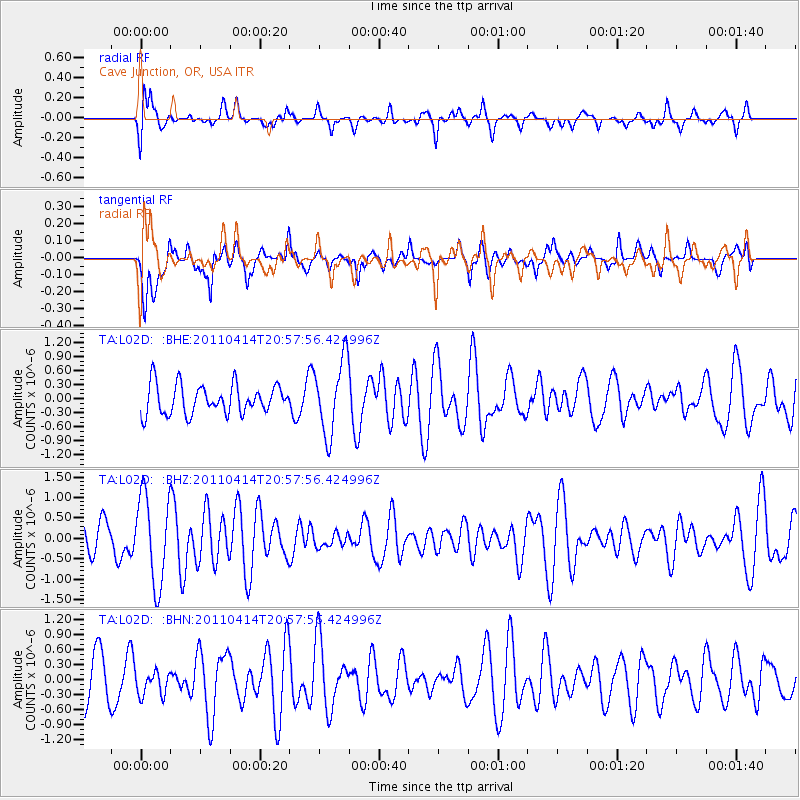
L02D Cave Junction, OR, USA - Earthquake Result Viewer
*The percent match for this event was below the threshold and hence no stack was calculated.
| Earthquake location: |
Near Coast Of Nicaragua |
| Earthquake latitude/longitude: |
11.2/-86.4 |
| Earthquake time(UTC): |
2011/04/14 (104) 20:50:16 GMT |
| Earthquake Depth: |
35 km |
| Earthquake Magnitude: |
5.6 MB, 5.4 MS, 5.7 MW, 5.6 MW |
| Earthquake Catalog/Contributor: |
WHDF/NEIC |
|
| Network: |
TA USArray Transportable Network (new EarthScope stations) |
| Station: |
L02D Cave Junction, OR, USA |
| Lat/Lon: |
42.16 N/123.60 W |
| Elevation: |
458 m |
|
| Distance: |
44.8 deg |
| Az: |
320.307 deg |
| Baz: |
122.553 deg |
| Ray Param: |
$rayparam |
*The percent match for this event was below the threshold and hence was not used in the summary stack. |
|
| Radial Match: |
77.74992 % |
| Radial Bump: |
400 |
| Transverse Match: |
44.31988 % |
| Transverse Bump: |
357 |
| SOD ConfigId: |
356183 |
| Insert Time: |
2011-09-27 16:50:22.233 +0000 |
| GWidth: |
2.5 |
| Max Bumps: |
400 |
| Tol: |
0.001 |
|
Signal To Noise
| Channel | StoN | STA | LTA |
| TA:L02D: :BHZ:20110414T20:57:56.424996Z | 2.2379408 | 1.0838495E-6 | 4.843066E-7 |
| TA:L02D: :BHN:20110414T20:57:56.424996Z | 0.58064145 | 2.4089658E-7 | 4.148801E-7 |
| TA:L02D: :BHE:20110414T20:57:56.424996Z | 2.5291793 | 7.8571105E-7 | 3.106585E-7 |
| Arrivals |
| Ps | |
| PpPs | |
| PsPs/PpSs | |


