You are here: Home > Network List > TA - USArray Transportable Network (new EarthScope stations) Stations List
> Station L32A Elgin, NE, USA > Earthquake Result Viewer
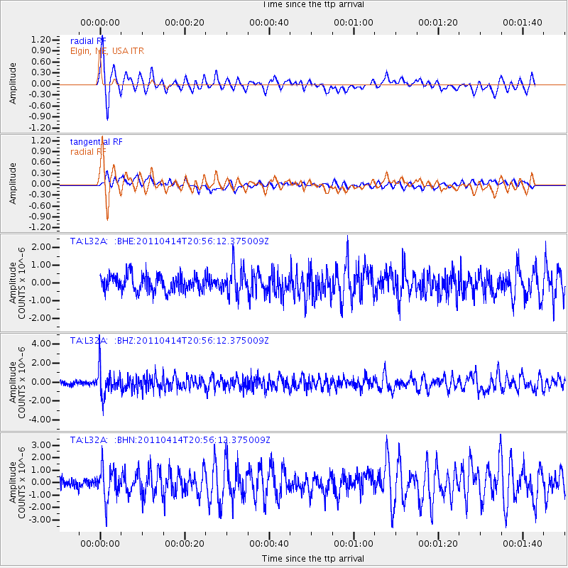
L32A Elgin, NE, USA - Earthquake Result Viewer
*The percent match for this event was below the threshold and hence no stack was calculated.
| Earthquake location: |
Near Coast Of Nicaragua |
| Earthquake latitude/longitude: |
11.2/-86.4 |
| Earthquake time(UTC): |
2011/04/14 (104) 20:50:16 GMT |
| Earthquake Depth: |
35 km |
| Earthquake Magnitude: |
5.6 MB, 5.4 MS, 5.7 MW, 5.6 MW |
| Earthquake Catalog/Contributor: |
WHDF/NEIC |
|
| Network: |
TA USArray Transportable Network (new EarthScope stations) |
| Station: |
L32A Elgin, NE, USA |
| Lat/Lon: |
42.00 N/98.01 W |
| Elevation: |
586 m |
|
| Distance: |
32.4 deg |
| Az: |
343.663 deg |
| Baz: |
158.263 deg |
| Ray Param: |
$rayparam |
*The percent match for this event was below the threshold and hence was not used in the summary stack. |
|
| Radial Match: |
75.630714 % |
| Radial Bump: |
397 |
| Transverse Match: |
65.68416 % |
| Transverse Bump: |
400 |
| SOD ConfigId: |
356183 |
| Insert Time: |
2011-09-27 16:55:57.463 +0000 |
| GWidth: |
2.5 |
| Max Bumps: |
400 |
| Tol: |
0.001 |
|
Signal To Noise
| Channel | StoN | STA | LTA |
| TA:L32A: :BHZ:20110414T20:56:12.375009Z | 5.6711817 | 1.4789308E-6 | 2.6078E-7 |
| TA:L32A: :BHN:20110414T20:56:12.375009Z | 3.052484 | 1.2533973E-6 | 4.1061548E-7 |
| TA:L32A: :BHE:20110414T20:56:12.375009Z | 1.7601604 | 7.9517054E-7 | 4.5176026E-7 |
| Arrivals |
| Ps | |
| PpPs | |
| PsPs/PpSs | |


