You are here: Home > Network List > TA - USArray Transportable Network (new EarthScope stations) Stations List
> Station E35A Pequot Lakes, MN, USA > Earthquake Result Viewer
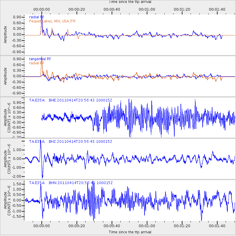
E35A Pequot Lakes, MN, USA - Earthquake Result Viewer
*The percent match for this event was below the threshold and hence no stack was calculated.
| Earthquake location: |
Near Coast Of Nicaragua |
| Earthquake latitude/longitude: |
11.2/-86.4 |
| Earthquake time(UTC): |
2011/04/14 (104) 20:50:16 GMT |
| Earthquake Depth: |
35 km |
| Earthquake Magnitude: |
5.6 MB, 5.4 MS, 5.7 MW, 5.6 MW |
| Earthquake Catalog/Contributor: |
WHDF/NEIC |
|
| Network: |
TA USArray Transportable Network (new EarthScope stations) |
| Station: |
E35A Pequot Lakes, MN, USA |
| Lat/Lon: |
46.56 N/94.40 W |
| Elevation: |
409 m |
|
| Distance: |
35.9 deg |
| Az: |
350.517 deg |
| Baz: |
166.45 deg |
| Ray Param: |
$rayparam |
*The percent match for this event was below the threshold and hence was not used in the summary stack. |
|
| Radial Match: |
68.86852 % |
| Radial Bump: |
400 |
| Transverse Match: |
66.11222 % |
| Transverse Bump: |
400 |
| SOD ConfigId: |
356183 |
| Insert Time: |
2011-09-27 17:05:31.741 +0000 |
| GWidth: |
2.5 |
| Max Bumps: |
400 |
| Tol: |
0.001 |
|
Signal To Noise
| Channel | StoN | STA | LTA |
| TA:E35A: :BHZ:20110414T20:56:43.100015Z | 7.907595 | 9.17489E-7 | 1.1602629E-7 |
| TA:E35A: :BHN:20110414T20:56:43.100015Z | 4.01918 | 6.569803E-7 | 1.6346128E-7 |
| TA:E35A: :BHE:20110414T20:56:43.100015Z | 3.5655925 | 4.0795587E-7 | 1.14414604E-7 |
| Arrivals |
| Ps | |
| PpPs | |
| PsPs/PpSs | |


