You are here: Home > Network List > TA - USArray Transportable Network (new EarthScope stations) Stations List
> Station H36A Jessenland, Henderson, MN, USA > Earthquake Result Viewer
H36A Jessenland, Henderson, MN, USA - Earthquake Result Viewer
*The percent match for this event was below the threshold and hence no stack was calculated.
| Earthquake location: |
Near Coast Of Nicaragua |
| Earthquake latitude/longitude: |
11.2/-86.4 |
| Earthquake time(UTC): |
2011/04/14 (104) 20:50:16 GMT |
| Earthquake Depth: |
35 km |
| Earthquake Magnitude: |
5.6 MB, 5.4 MS, 5.7 MW, 5.6 MW |
| Earthquake Catalog/Contributor: |
WHDF/NEIC |
|
| Network: |
TA USArray Transportable Network (new EarthScope stations) |
| Station: |
H36A Jessenland, Henderson, MN, USA |
| Lat/Lon: |
44.58 N/93.93 W |
| Elevation: |
311 m |
|
| Distance: |
33.9 deg |
| Az: |
350.279 deg |
| Baz: |
166.594 deg |
| Ray Param: |
$rayparam |
*The percent match for this event was below the threshold and hence was not used in the summary stack. |
|
| Radial Match: |
59.76601 % |
| Radial Bump: |
400 |
| Transverse Match: |
56.656662 % |
| Transverse Bump: |
400 |
| SOD ConfigId: |
356183 |
| Insert Time: |
2011-09-27 17:12:44.648 +0000 |
| GWidth: |
2.5 |
| Max Bumps: |
400 |
| Tol: |
0.001 |
|
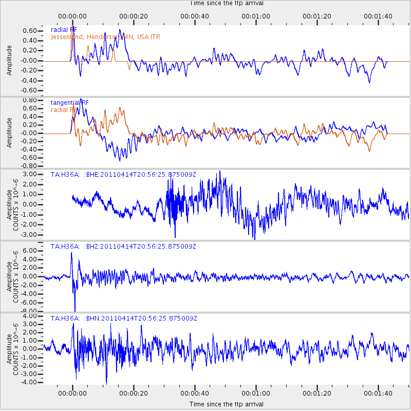
Signal To Noise
| Channel | StoN | STA | LTA |
| TA:H36A: :BHZ:20110414T20:56:25.875009Z | 9.195293 | 2.4674187E-6 | 2.6833496E-7 |
| TA:H36A: :BHN:20110414T20:56:25.875009Z | 2.9404733 | 1.431681E-6 | 4.868879E-7 |
| TA:H36A: :BHE:20110414T20:56:25.875009Z | 1.9784383 | 1.1960258E-6 | 6.045302E-7 |
| Arrivals |
| Ps | |
| PpPs | |
| PsPs/PpSs | |


