You are here: Home > Network List > TA - USArray Transportable Network (new EarthScope stations) Stations List
> Station G54A Lake Saint Peter, ON, CAN > Earthquake Result Viewer
G54A Lake Saint Peter, ON, CAN - Earthquake Result Viewer
| Earthquake location: |
Off Coast Of Guerrero, Mexico |
| Earthquake latitude/longitude: |
15.9/-98.5 |
| Earthquake time(UTC): |
2014/03/10 (069) 00:37:58 GMT |
| Earthquake Depth: |
23 km |
| Earthquake Magnitude: |
3.9 mb |
| Earthquake Catalog/Contributor: |
ISC/ISC |
|
| Network: |
TA USArray Transportable Network (new EarthScope stations) |
| Station: |
G54A Lake Saint Peter, ON, CAN |
| Lat/Lon: |
45.40 N/78.09 W |
| Elevation: |
465 m |
|
| Distance: |
34.1 deg |
| Az: |
25.965 deg |
| Baz: |
216.731 deg |
| Ray Param: |
0.07788951 |
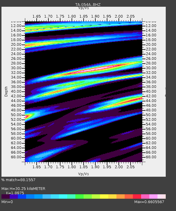
| Estimated Moho Depth: |
30.25 km |
| Estimated Crust Vp/Vs: |
1.90 |
| Assumed Crust Vp: |
6.577 km/s |
| Estimated Crust Vs: |
3.466 km/s |
| Estimated Crust Poisson's Ratio: |
0.31 |
|
| Radial Match: |
88.1557 % |
| Radial Bump: |
400 |
| Transverse Match: |
53.97587 % |
| Transverse Bump: |
400 |
| SOD ConfigId: |
3390531 |
| Insert Time: |
2019-04-10 14:01:33.771 +0000 |
| GWidth: |
2.5 |
| Max Bumps: |
400 |
| Tol: |
0.001 |
|

Signal To Noise
| Channel | StoN | STA | LTA |
| TA:G54A: :BHZ:20140310T00:44:10.424993Z | 1.800421 | 3.5457168E-7 | 1.9693822E-7 |
| TA:G54A: :BHN:20140310T00:44:10.424993Z | 1.173214 | 1.642979E-7 | 1.4004087E-7 |
| TA:G54A: :BHE:20140310T00:44:10.424993Z | 0.47220197 | 6.731983E-8 | 1.4256577E-7 |
| Arrivals |
| Ps | 4.5 SECOND |
| PpPs | 12 SECOND |
| PsPs/PpSs | 17 SECOND |


