You are here: Home > Network List > TA - USArray Transportable Network (new EarthScope stations) Stations List
> Station F32A Veblen, SD, USA > Earthquake Result Viewer
F32A Veblen, SD, USA - Earthquake Result Viewer
| Earthquake location: |
Near Coast Of Nicaragua |
| Earthquake latitude/longitude: |
11.2/-86.4 |
| Earthquake time(UTC): |
2011/04/14 (104) 20:50:16 GMT |
| Earthquake Depth: |
35 km |
| Earthquake Magnitude: |
5.6 MB, 5.4 MS, 5.7 MW, 5.6 MW |
| Earthquake Catalog/Contributor: |
WHDF/NEIC |
|
| Network: |
TA USArray Transportable Network (new EarthScope stations) |
| Station: |
F32A Veblen, SD, USA |
| Lat/Lon: |
45.87 N/97.13 W |
| Elevation: |
371 m |
|
| Distance: |
35.8 deg |
| Az: |
347.092 deg |
| Baz: |
161.715 deg |
| Ray Param: |
0.07697102 |
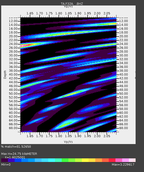
| Estimated Moho Depth: |
24.75 km |
| Estimated Crust Vp/Vs: |
1.60 |
| Assumed Crust Vp: |
6.552 km/s |
| Estimated Crust Vs: |
4.089 km/s |
| Estimated Crust Poisson's Ratio: |
0.18 |
|
| Radial Match: |
81.52658 % |
| Radial Bump: |
400 |
| Transverse Match: |
65.73032 % |
| Transverse Bump: |
400 |
| SOD ConfigId: |
356183 |
| Insert Time: |
2011-09-27 17:18:19.369 +0000 |
| GWidth: |
2.5 |
| Max Bumps: |
400 |
| Tol: |
0.001 |
|
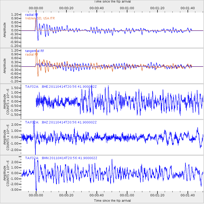
Signal To Noise
| Channel | StoN | STA | LTA |
| TA:F32A: :BHZ:20110414T20:56:41.900002Z | 1.8043953 | 7.176455E-7 | 3.9772078E-7 |
| TA:F32A: :BHN:20110414T20:56:41.900002Z | 4.1800585 | 1.5192916E-6 | 3.6346182E-7 |
| TA:F32A: :BHE:20110414T20:56:41.900002Z | 2.1317675 | 7.069094E-7 | 3.316072E-7 |
| Arrivals |
| Ps | 2.5 SECOND |
| PpPs | 9.0 SECOND |
| PsPs/PpSs | 11 SECOND |


