You are here: Home > Network List > TA - USArray Transportable Network (new EarthScope stations) Stations List
> Station H46A Fife Lake, MI, USA > Earthquake Result Viewer
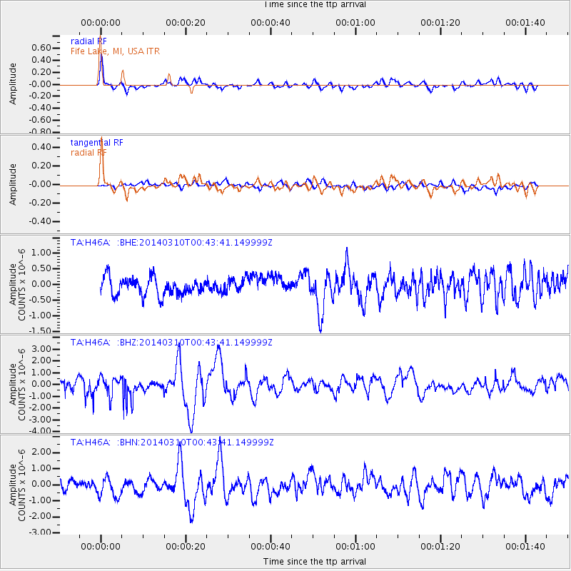
H46A Fife Lake, MI, USA - Earthquake Result Viewer
*The percent match for this event was below the threshold and hence no stack was calculated.
| Earthquake location: |
Off Coast Of Guerrero, Mexico |
| Earthquake latitude/longitude: |
15.9/-98.5 |
| Earthquake time(UTC): |
2014/03/10 (069) 00:37:58 GMT |
| Earthquake Depth: |
23 km |
| Earthquake Magnitude: |
3.9 mb |
| Earthquake Catalog/Contributor: |
ISC/ISC |
|
| Network: |
TA USArray Transportable Network (new EarthScope stations) |
| Station: |
H46A Fife Lake, MI, USA |
| Lat/Lon: |
44.54 N/85.20 W |
| Elevation: |
329 m |
|
| Distance: |
30.7 deg |
| Az: |
18.727 deg |
| Baz: |
205.6 deg |
| Ray Param: |
$rayparam |
*The percent match for this event was below the threshold and hence was not used in the summary stack. |
|
| Radial Match: |
60.539963 % |
| Radial Bump: |
359 |
| Transverse Match: |
39.95983 % |
| Transverse Bump: |
400 |
| SOD ConfigId: |
3390531 |
| Insert Time: |
2019-04-10 14:01:36.527 +0000 |
| GWidth: |
2.5 |
| Max Bumps: |
400 |
| Tol: |
0.001 |
|
Signal To Noise
| Channel | StoN | STA | LTA |
| TA:H46A: :BHZ:20140310T00:43:41.149999Z | 1.7214504 | 7.854084E-7 | 4.5624805E-7 |
| TA:H46A: :BHN:20140310T00:43:41.149999Z | 1.7074239 | 6.5754307E-7 | 3.8510825E-7 |
| TA:H46A: :BHE:20140310T00:43:41.149999Z | 0.82642794 | 2.2845707E-7 | 2.7643918E-7 |
| Arrivals |
| Ps | |
| PpPs | |
| PsPs/PpSs | |


