You are here: Home > Network List > US - United States National Seismic Network Stations List
> Station CBKS Cedar Bluff, Kansas, USA > Earthquake Result Viewer
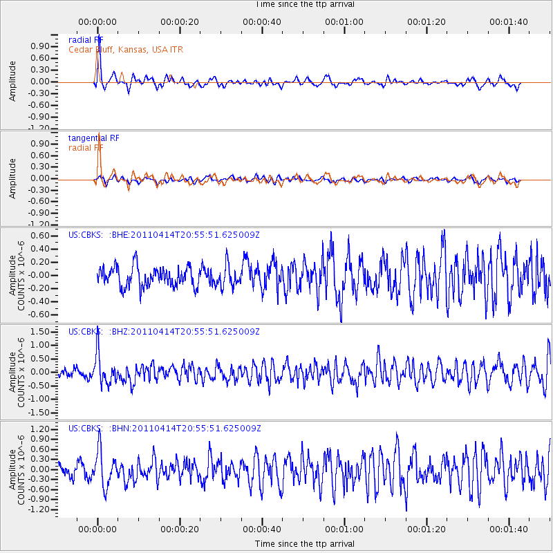
CBKS Cedar Bluff, Kansas, USA - Earthquake Result Viewer
*The percent match for this event was below the threshold and hence no stack was calculated.
| Earthquake location: |
Near Coast Of Nicaragua |
| Earthquake latitude/longitude: |
11.2/-86.4 |
| Earthquake time(UTC): |
2011/04/14 (104) 20:50:16 GMT |
| Earthquake Depth: |
35 km |
| Earthquake Magnitude: |
5.6 MB, 5.4 MS, 5.7 MW, 5.6 MW |
| Earthquake Catalog/Contributor: |
WHDF/NEIC |
|
| Network: |
US United States National Seismic Network |
| Station: |
CBKS Cedar Bluff, Kansas, USA |
| Lat/Lon: |
38.81 N/99.74 W |
| Elevation: |
677 m |
|
| Distance: |
30.0 deg |
| Az: |
338.799 deg |
| Baz: |
152.983 deg |
| Ray Param: |
$rayparam |
*The percent match for this event was below the threshold and hence was not used in the summary stack. |
|
| Radial Match: |
74.46521 % |
| Radial Bump: |
400 |
| Transverse Match: |
44.823345 % |
| Transverse Bump: |
393 |
| SOD ConfigId: |
356183 |
| Insert Time: |
2011-09-27 17:25:44.796 +0000 |
| GWidth: |
2.5 |
| Max Bumps: |
400 |
| Tol: |
0.001 |
|
Signal To Noise
| Channel | StoN | STA | LTA |
| US:CBKS: :BHZ:20110414T20:55:51.625009Z | 3.9016218 | 5.8317806E-7 | 1.4947068E-7 |
| US:CBKS: :BHN:20110414T20:55:51.625009Z | 3.279129 | 5.4301137E-7 | 1.6559622E-7 |
| US:CBKS: :BHE:20110414T20:55:51.625009Z | 1.0908965 | 1.5994328E-7 | 1.4661639E-7 |
| Arrivals |
| Ps | |
| PpPs | |
| PsPs/PpSs | |


