You are here: Home > Network List > UW - Pacific Northwest Regional Seismic Network Stations List
> Station MRBL Marblemount, WA, USA > Earthquake Result Viewer
MRBL Marblemount, WA, USA - Earthquake Result Viewer
*The percent match for this event was below the threshold and hence no stack was calculated.
| Earthquake location: |
Near Coast Of Nicaragua |
| Earthquake latitude/longitude: |
11.2/-86.4 |
| Earthquake time(UTC): |
2011/04/14 (104) 20:50:16 GMT |
| Earthquake Depth: |
35 km |
| Earthquake Magnitude: |
5.6 MB, 5.4 MS, 5.7 MW, 5.6 MW |
| Earthquake Catalog/Contributor: |
WHDF/NEIC |
|
| Network: |
UW Pacific Northwest Regional Seismic Network |
| Station: |
MRBL Marblemount, WA, USA |
| Lat/Lon: |
48.52 N/121.48 W |
| Elevation: |
75 m |
|
| Distance: |
47.4 deg |
| Az: |
328.66 deg |
| Baz: |
129.858 deg |
| Ray Param: |
$rayparam |
*The percent match for this event was below the threshold and hence was not used in the summary stack. |
|
| Radial Match: |
65.946785 % |
| Radial Bump: |
400 |
| Transverse Match: |
63.27882 % |
| Transverse Bump: |
400 |
| SOD ConfigId: |
356183 |
| Insert Time: |
2011-09-27 17:34:02.840 +0000 |
| GWidth: |
2.5 |
| Max Bumps: |
400 |
| Tol: |
0.001 |
|
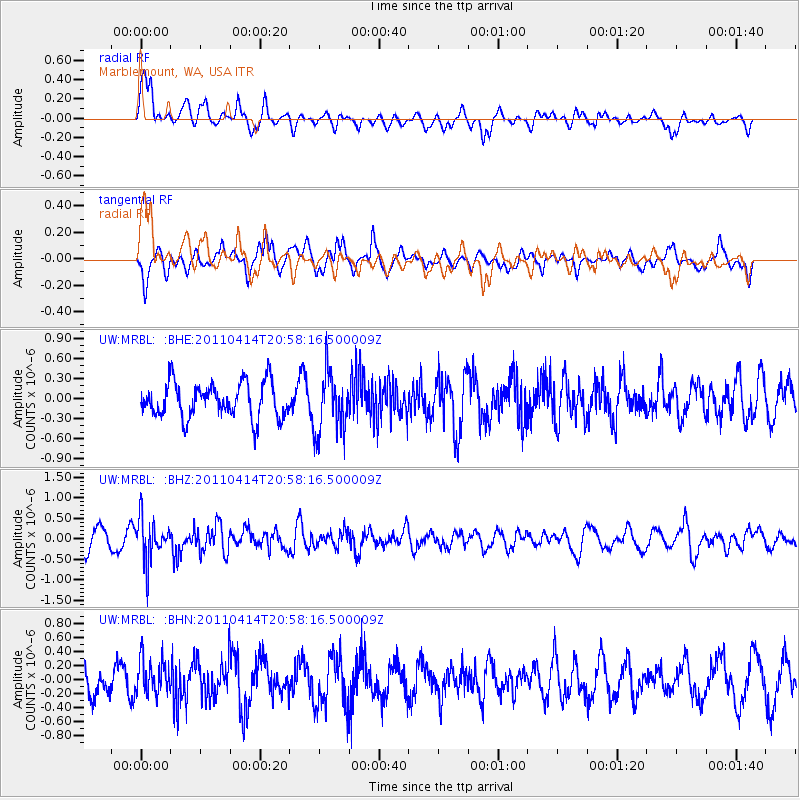
Signal To Noise
| Channel | StoN | STA | LTA |
| UW:MRBL: :BHZ:20110414T20:58:16.500009Z | 2.4458334 | 5.161172E-7 | 2.1101896E-7 |
| UW:MRBL: :BHN:20110414T20:58:16.500009Z | 1.2129583 | 2.5079558E-7 | 2.0676356E-7 |
| UW:MRBL: :BHE:20110414T20:58:16.500009Z | 1.7783775 | 4.6133115E-7 | 2.5941125E-7 |
| Arrivals |
| Ps | |
| PpPs | |
| PsPs/PpSs | |


