You are here: Home > Network List > AZ - ANZA Regional Network Stations List
> Station SMER AZ.SMER > Earthquake Result Viewer
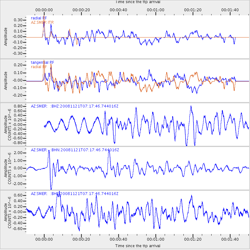
SMER AZ.SMER - Earthquake Result Viewer
*The percent match for this event was below the threshold and hence no stack was calculated.
| Earthquake location: |
Solomon Islands |
| Earthquake latitude/longitude: |
-8.9/159.6 |
| Earthquake time(UTC): |
2008/11/21 (326) 07:05:34 GMT |
| Earthquake Depth: |
118 km |
| Earthquake Magnitude: |
6.0 MB, 6.1 MW, 6.0 MW |
| Earthquake Catalog/Contributor: |
WHDF/NEIC |
|
| Network: |
AZ ANZA Regional Network |
| Station: |
SMER AZ.SMER |
| Lat/Lon: |
33.46 N/117.17 W |
| Elevation: |
355 m |
|
| Distance: |
89.3 deg |
| Az: |
56.129 deg |
| Baz: |
258.892 deg |
| Ray Param: |
$rayparam |
*The percent match for this event was below the threshold and hence was not used in the summary stack. |
|
| Radial Match: |
67.41077 % |
| Radial Bump: |
400 |
| Transverse Match: |
46.94564 % |
| Transverse Bump: |
400 |
| SOD ConfigId: |
2658 |
| Insert Time: |
2010-02-26 20:48:32.043 +0000 |
| GWidth: |
2.5 |
| Max Bumps: |
400 |
| Tol: |
0.001 |
|
Signal To Noise
| Channel | StoN | STA | LTA |
| AZ:SMER: :BHN:20081121T07:17:46.744016Z | 6.7768044 | 1.3297908E-6 | 1.9622682E-7 |
| AZ:SMER: :BHE:20081121T07:17:46.744016Z | 0.88332015 | 1.4996304E-7 | 1.6977201E-7 |
| AZ:SMER: :BHZ:20081121T07:17:46.744016Z | 1.3851871 | 2.8607204E-7 | 2.065223E-7 |
| Arrivals |
| Ps | |
| PpPs | |
| PsPs/PpSs | |


