You are here: Home > Network List > BK - Berkeley Digital Seismograph Network Stations List
> Station HUMO Hull Mountain, OR > Earthquake Result Viewer
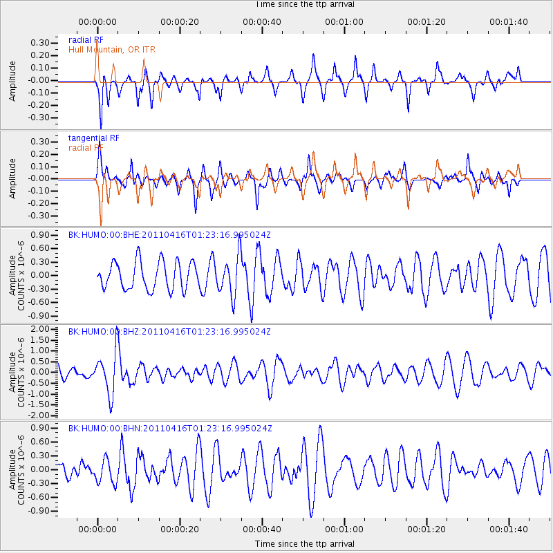
HUMO Hull Mountain, OR - Earthquake Result Viewer
*The percent match for this event was below the threshold and hence no stack was calculated.
| Earthquake location: |
Northeast Of Taiwan |
| Earthquake latitude/longitude: |
25.4/123.9 |
| Earthquake time(UTC): |
2011/04/16 (106) 01:11:10 GMT |
| Earthquake Depth: |
134 km |
| Earthquake Magnitude: |
5.9 MB, 5.8 MW, 5.8 MW |
| Earthquake Catalog/Contributor: |
WHDF/NEIC |
|
| Network: |
BK Berkeley Digital Seismograph Network |
| Station: |
HUMO Hull Mountain, OR |
| Lat/Lon: |
42.61 N/122.96 W |
| Elevation: |
555 m |
|
| Distance: |
88.5 deg |
| Az: |
42.769 deg |
| Baz: |
303.724 deg |
| Ray Param: |
$rayparam |
*The percent match for this event was below the threshold and hence was not used in the summary stack. |
|
| Radial Match: |
61.566227 % |
| Radial Bump: |
279 |
| Transverse Match: |
66.402 % |
| Transverse Bump: |
305 |
| SOD ConfigId: |
356183 |
| Insert Time: |
2011-09-30 03:23:06.288 +0000 |
| GWidth: |
2.5 |
| Max Bumps: |
400 |
| Tol: |
0.001 |
|
Signal To Noise
| Channel | StoN | STA | LTA |
| BK:HUMO:00:BHZ:20110416T01:23:16.995024Z | 2.0693192 | 9.826277E-7 | 4.7485554E-7 |
| BK:HUMO:00:BHN:20110416T01:23:16.995024Z | 1.1616136 | 2.5320213E-7 | 2.1797449E-7 |
| BK:HUMO:00:BHE:20110416T01:23:16.995024Z | 1.4827995 | 4.4981482E-7 | 3.033551E-7 |
| Arrivals |
| Ps | |
| PpPs | |
| PsPs/PpSs | |


