You are here: Home > Network List > TA - USArray Transportable Network (new EarthScope stations) Stations List
> Station K50A Casco, MI, USA > Earthquake Result Viewer
K50A Casco, MI, USA - Earthquake Result Viewer
| Earthquake location: |
Near Coast Of Guerrero, Mexico |
| Earthquake latitude/longitude: |
16.0/-98.3 |
| Earthquake time(UTC): |
2014/03/10 (069) 00:38:15 GMT |
| Earthquake Depth: |
8.4 km |
| Earthquake Magnitude: |
5.8 MWW, 5.9 MWC, 6.0 MWB |
| Earthquake Catalog/Contributor: |
NEIC PDE/NEIC COMCAT |
|
| Network: |
TA USArray Transportable Network (new EarthScope stations) |
| Station: |
K50A Casco, MI, USA |
| Lat/Lon: |
42.77 N/82.62 W |
| Elevation: |
191 m |
|
| Distance: |
29.8 deg |
| Az: |
23.619 deg |
| Baz: |
211.549 deg |
| Ray Param: |
0.07948928 |
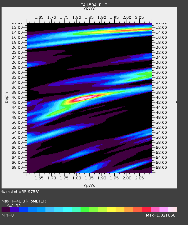
| Estimated Moho Depth: |
40.0 km |
| Estimated Crust Vp/Vs: |
1.83 |
| Assumed Crust Vp: |
6.483 km/s |
| Estimated Crust Vs: |
3.542 km/s |
| Estimated Crust Poisson's Ratio: |
0.29 |
|
| Radial Match: |
85.97551 % |
| Radial Bump: |
359 |
| Transverse Match: |
63.054626 % |
| Transverse Bump: |
400 |
| SOD ConfigId: |
3390531 |
| Insert Time: |
2019-04-10 14:05:16.302 +0000 |
| GWidth: |
2.5 |
| Max Bumps: |
400 |
| Tol: |
0.001 |
|
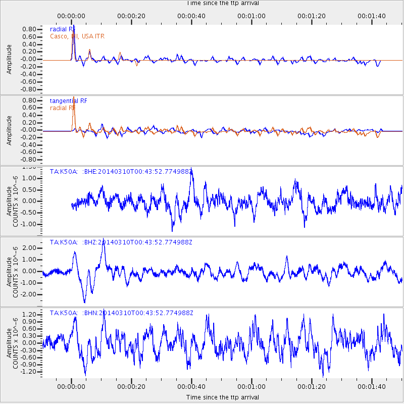
Signal To Noise
| Channel | StoN | STA | LTA |
| TA:K50A: :BHZ:20140310T00:43:52.774988Z | 7.6544695 | 1.2982478E-6 | 1.696065E-7 |
| TA:K50A: :BHN:20140310T00:43:52.774988Z | 2.7432222 | 7.003459E-7 | 2.5530045E-7 |
| TA:K50A: :BHE:20140310T00:43:52.774988Z | 2.3905792 | 5.156616E-7 | 2.1570571E-7 |
| Arrivals |
| Ps | 5.5 SECOND |
| PpPs | 16 SECOND |
| PsPs/PpSs | 22 SECOND |


