You are here: Home > Network List > X812 - Deep Structure of Three Continental Sutures in Eastern North America Stations List
> Station QM30 Fish River Lake, Maine, USA > Earthquake Result Viewer
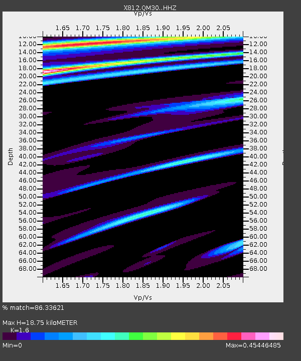
QM30 Fish River Lake, Maine, USA - Earthquake Result Viewer
| Earthquake location: |
Near Coast Of Guerrero, Mexico |
| Earthquake latitude/longitude: |
16.0/-98.3 |
| Earthquake time(UTC): |
2014/03/10 (069) 00:38:15 GMT |
| Earthquake Depth: |
8.4 km |
| Earthquake Magnitude: |
5.8 MWW, 5.9 MWC, 6.0 MWB |
| Earthquake Catalog/Contributor: |
NEIC PDE/NEIC COMCAT |
|
| Network: |
X8 Deep Structure of Three Continental Sutures in Eastern North America |
| Station: |
QM30 Fish River Lake, Maine, USA |
| Lat/Lon: |
46.83 N/68.76 W |
| Elevation: |
262 m |
|
| Distance: |
39.3 deg |
| Az: |
32.343 deg |
| Baz: |
228.527 deg |
| Ray Param: |
0.07506755 |
| Estimated Moho Depth: |
18.75 km |
| Estimated Crust Vp/Vs: |
1.60 |
| Assumed Crust Vp: |
6.419 km/s |
| Estimated Crust Vs: |
4.012 km/s |
| Estimated Crust Poisson's Ratio: |
0.18 |
|
| Radial Match: |
86.33621 % |
| Radial Bump: |
364 |
| Transverse Match: |
72.86004 % |
| Transverse Bump: |
400 |
| SOD ConfigId: |
3390531 |
| Insert Time: |
2019-04-10 14:05:45.642 +0000 |
| GWidth: |
2.5 |
| Max Bumps: |
400 |
| Tol: |
0.001 |
|

Signal To Noise
| Channel | StoN | STA | LTA |
| X8:QM30: :HHZ:20140310T00:45:14.100Z | 2.3466582 | 7.995868E-7 | 3.4073423E-7 |
| X8:QM30: :HHN:20140310T00:45:14.100Z | 1.5848534 | 5.0636294E-7 | 3.1950145E-7 |
| X8:QM30: :HHE:20140310T00:45:14.100Z | 1.7592921 | 5.0943174E-7 | 2.8956632E-7 |
| Arrivals |
| Ps | 1.9 SECOND |
| PpPs | 7.0 SECOND |
| PsPs/PpSs | 8.9 SECOND |


