You are here: Home > Network List > MN - MEDNET Project Stations List
> Station TIR Tirana, Albania > Earthquake Result Viewer
TIR Tirana, Albania - Earthquake Result Viewer
| Earthquake location: |
Northeast Of Taiwan |
| Earthquake latitude/longitude: |
25.4/123.9 |
| Earthquake time(UTC): |
2011/04/16 (106) 01:11:10 GMT |
| Earthquake Depth: |
134 km |
| Earthquake Magnitude: |
5.9 MB, 5.8 MW, 5.8 MW |
| Earthquake Catalog/Contributor: |
WHDF/NEIC |
|
| Network: |
MN MEDNET Project |
| Station: |
TIR Tirana, Albania |
| Lat/Lon: |
41.35 N/19.86 E |
| Elevation: |
247 m |
|
| Distance: |
83.3 deg |
| Az: |
312.657 deg |
| Baz: |
62.038 deg |
| Ray Param: |
0.045947615 |
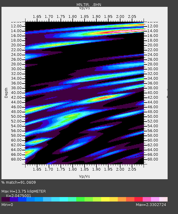
| Estimated Moho Depth: |
13.75 km |
| Estimated Crust Vp/Vs: |
2.05 |
| Assumed Crust Vp: |
5.967 km/s |
| Estimated Crust Vs: |
2.914 km/s |
| Estimated Crust Poisson's Ratio: |
0.34 |
|
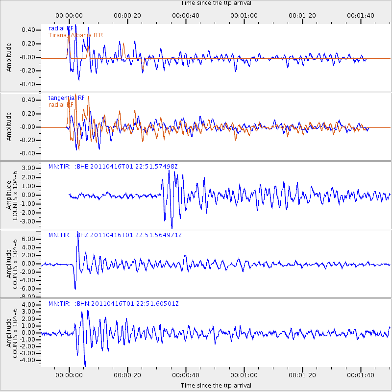
| Radial Match: |
91.0609 % |
| Radial Bump: |
400 |
| Transverse Match: |
86.903824 % |
| Transverse Bump: |
400 |
| SOD ConfigId: |
356183 |
| Insert Time: |
2011-09-30 03:35:13.258 +0000 |
| GWidth: |
2.5 |
| Max Bumps: |
400 |
| Tol: |
0.001 |
|
Signal To Noise
| Channel | StoN | STA | LTA |
| MN:TIR: :BHZ:20110416T01:22:51.564971Z | 20.527689 | 2.91641E-6 | 1.4207201E-7 |
| MN:TIR: :BHN:20110416T01:22:51.60501Z | 9.516743 | 1.3678537E-6 | 1.437313E-7 |
| MN:TIR: :BHE:20110416T01:22:51.57498Z | 7.93191 | 1.2593113E-6 | 1.5876519E-7 |
| Arrivals |
| Ps | 2.5 SECOND |
| PpPs | 6.9 SECOND |
| PsPs/PpSs | 9.4 SECOND |


