You are here: Home > Network List > X812 - Deep Structure of Three Continental Sutures in Eastern North America Stations List
> Station QMPO Pohenegamook, Quebec, Canada > Earthquake Result Viewer
QMPO Pohenegamook, Quebec, Canada - Earthquake Result Viewer
| Earthquake location: |
Near Coast Of Guerrero, Mexico |
| Earthquake latitude/longitude: |
16.0/-98.3 |
| Earthquake time(UTC): |
2014/03/10 (069) 00:38:15 GMT |
| Earthquake Depth: |
8.4 km |
| Earthquake Magnitude: |
5.8 MWW, 5.9 MWC, 6.0 MWB |
| Earthquake Catalog/Contributor: |
NEIC PDE/NEIC COMCAT |
|
| Network: |
X8 Deep Structure of Three Continental Sutures in Eastern North America |
| Station: |
QMPO Pohenegamook, Quebec, Canada |
| Lat/Lon: |
47.53 N/69.36 W |
| Elevation: |
430 m |
|
| Distance: |
39.5 deg |
| Az: |
31.092 deg |
| Baz: |
227.12 deg |
| Ray Param: |
0.074970715 |
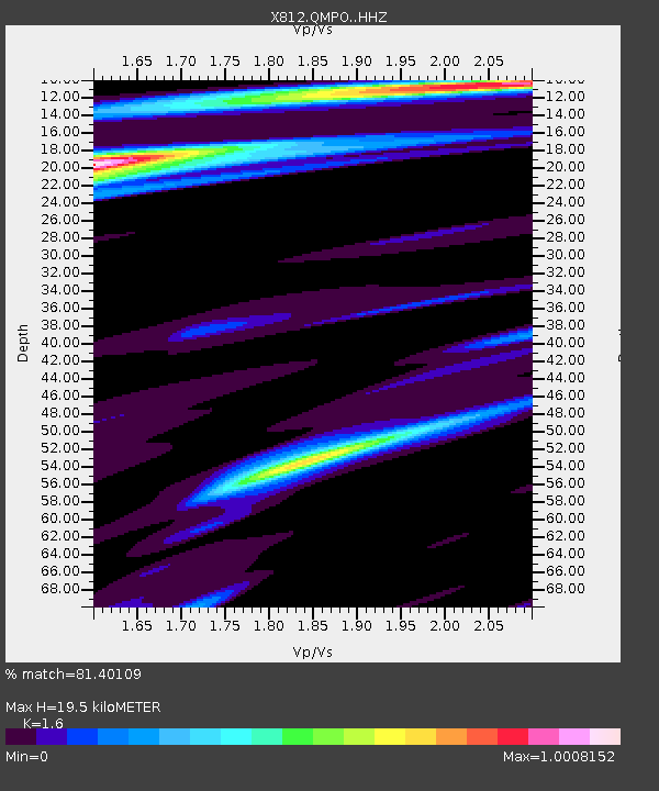
| Estimated Moho Depth: |
19.5 km |
| Estimated Crust Vp/Vs: |
1.60 |
| Assumed Crust Vp: |
6.419 km/s |
| Estimated Crust Vs: |
4.012 km/s |
| Estimated Crust Poisson's Ratio: |
0.18 |
|
| Radial Match: |
81.40109 % |
| Radial Bump: |
400 |
| Transverse Match: |
46.213627 % |
| Transverse Bump: |
400 |
| SOD ConfigId: |
3390531 |
| Insert Time: |
2019-04-10 14:05:58.691 +0000 |
| GWidth: |
2.5 |
| Max Bumps: |
400 |
| Tol: |
0.001 |
|

Signal To Noise
| Channel | StoN | STA | LTA |
| X8:QMPO: :HHZ:20140310T00:45:15.504999Z | 3.3159704 | 9.429266E-7 | 2.8435917E-7 |
| X8:QMPO: :HHN:20140310T00:45:15.504999Z | 1.839318 | 4.0211518E-7 | 2.1862189E-7 |
| X8:QMPO: :HHE:20140310T00:45:15.504999Z | 1.4177593 | 3.6410162E-7 | 2.5681484E-7 |
| Arrivals |
| Ps | 2.0 SECOND |
| PpPs | 7.3 SECOND |
| PsPs/PpSs | 9.3 SECOND |


