You are here: Home > Network List > MN - MEDNET Project Stations List
> Station TIP Timpagrande, Italy > Earthquake Result Viewer
TIP Timpagrande, Italy - Earthquake Result Viewer
| Earthquake location: |
Northeast Of Taiwan |
| Earthquake latitude/longitude: |
25.4/123.9 |
| Earthquake time(UTC): |
2011/04/16 (106) 01:11:10 GMT |
| Earthquake Depth: |
134 km |
| Earthquake Magnitude: |
5.9 MB, 5.8 MW, 5.8 MW |
| Earthquake Catalog/Contributor: |
WHDF/NEIC |
|
| Network: |
MN MEDNET Project |
| Station: |
TIP Timpagrande, Italy |
| Lat/Lon: |
39.18 N/16.76 E |
| Elevation: |
789 m |
|
| Distance: |
86.5 deg |
| Az: |
311.913 deg |
| Baz: |
59.973 deg |
| Ray Param: |
0.043729737 |
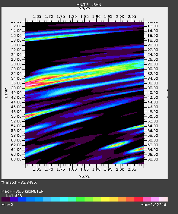
| Estimated Moho Depth: |
36.5 km |
| Estimated Crust Vp/Vs: |
1.62 |
| Assumed Crust Vp: |
6.1 km/s |
| Estimated Crust Vs: |
3.754 km/s |
| Estimated Crust Poisson's Ratio: |
0.20 |
|
| Radial Match: |
85.34957 % |
| Radial Bump: |
400 |
| Transverse Match: |
74.06119 % |
| Transverse Bump: |
400 |
| SOD ConfigId: |
356183 |
| Insert Time: |
2011-09-30 03:36:03.201 +0000 |
| GWidth: |
2.5 |
| Max Bumps: |
400 |
| Tol: |
0.001 |
|

Signal To Noise
| Channel | StoN | STA | LTA |
| MN:TIP: :BHZ:20110416T01:23:07.152007Z | 14.700075 | 1.5691528E-6 | 1.06744544E-7 |
| MN:TIP: :BHN:20110416T01:23:07.152007Z | 3.2978663 | 3.1304447E-7 | 9.492334E-8 |
| MN:TIP: :BHE:20110416T01:23:07.152007Z | 5.025821 | 5.0426513E-7 | 1.0033488E-7 |
| Arrivals |
| Ps | 3.8 SECOND |
| PpPs | 15 SECOND |
| PsPs/PpSs | 19 SECOND |


