You are here: Home > Network List > TA - USArray Transportable Network (new EarthScope stations) Stations List
> Station G26A Maurine, SD, USA > Earthquake Result Viewer
G26A Maurine, SD, USA - Earthquake Result Viewer
*The percent match for this event was below the threshold and hence no stack was calculated.
| Earthquake location: |
Northeast Of Taiwan |
| Earthquake latitude/longitude: |
25.4/123.9 |
| Earthquake time(UTC): |
2011/04/16 (106) 01:11:10 GMT |
| Earthquake Depth: |
134 km |
| Earthquake Magnitude: |
5.9 MB, 5.8 MW, 5.8 MW |
| Earthquake Catalog/Contributor: |
WHDF/NEIC |
|
| Network: |
TA USArray Transportable Network (new EarthScope stations) |
| Station: |
G26A Maurine, SD, USA |
| Lat/Lon: |
45.29 N/102.60 W |
| Elevation: |
833 m |
|
| Distance: |
97.9 deg |
| Az: |
31.118 deg |
| Baz: |
318.541 deg |
| Ray Param: |
$rayparam |
*The percent match for this event was below the threshold and hence was not used in the summary stack. |
|
| Radial Match: |
52.351147 % |
| Radial Bump: |
400 |
| Transverse Match: |
45.54493 % |
| Transverse Bump: |
400 |
| SOD ConfigId: |
356183 |
| Insert Time: |
2011-09-30 03:40:44.701 +0000 |
| GWidth: |
2.5 |
| Max Bumps: |
400 |
| Tol: |
0.001 |
|
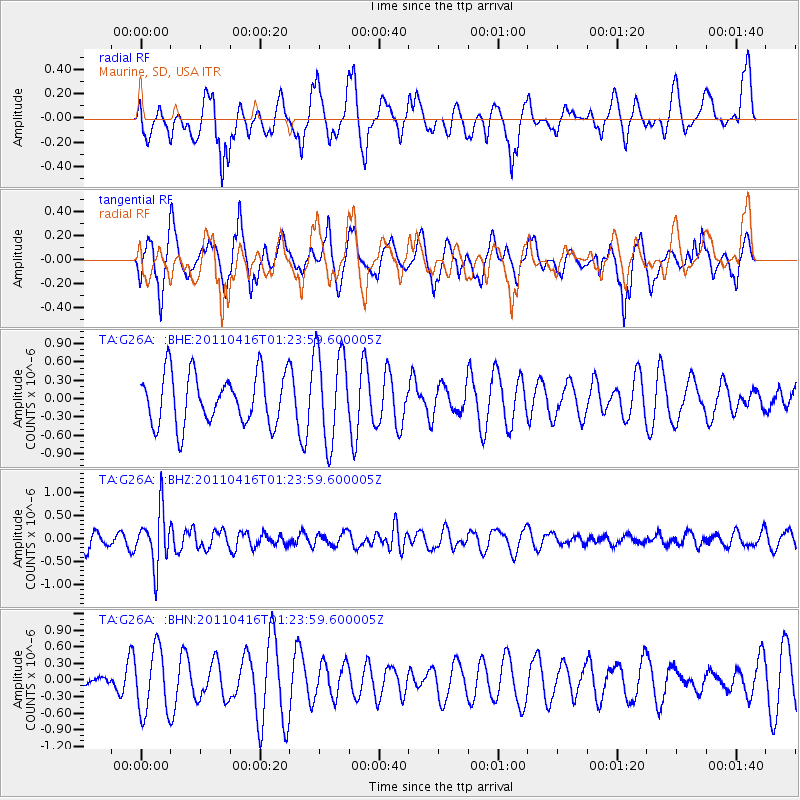
Signal To Noise
| Channel | StoN | STA | LTA |
| TA:G26A: :BHZ:20110416T01:23:59.600005Z | 2.536718 | 5.9101774E-7 | 2.329852E-7 |
| TA:G26A: :BHN:20110416T01:23:59.600005Z | 1.3508661 | 5.8488837E-7 | 4.3297285E-7 |
| TA:G26A: :BHE:20110416T01:23:59.600005Z | 1.8257754 | 7.5681936E-7 | 4.1451943E-7 |
| Arrivals |
| Ps | |
| PpPs | |
| PsPs/PpSs | |


