You are here: Home > Network List > AZ - ANZA Regional Network Stations List
> Station SMER AZ.SMER > Earthquake Result Viewer
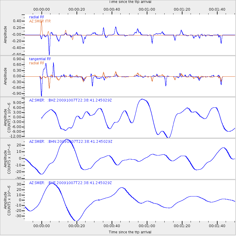
SMER AZ.SMER - Earthquake Result Viewer
*The percent match for this event was below the threshold and hence no stack was calculated.
| Earthquake location: |
Santa Cruz Islands |
| Earthquake latitude/longitude: |
-12.1/166.6 |
| Earthquake time(UTC): |
2009/10/07 (280) 22:26:38 GMT |
| Earthquake Depth: |
35 km |
| Earthquake Magnitude: |
5.6 MB |
| Earthquake Catalog/Contributor: |
WHDF/NEIC |
|
| Network: |
AZ ANZA Regional Network |
| Station: |
SMER AZ.SMER |
| Lat/Lon: |
33.46 N/117.17 W |
| Elevation: |
355 m |
|
| Distance: |
85.4 deg |
| Az: |
54.537 deg |
| Baz: |
252.35 deg |
| Ray Param: |
$rayparam |
*The percent match for this event was below the threshold and hence was not used in the summary stack. |
|
| Radial Match: |
87.65349 % |
| Radial Bump: |
392 |
| Transverse Match: |
65.37508 % |
| Transverse Bump: |
336 |
| SOD ConfigId: |
2622 |
| Insert Time: |
2010-02-26 20:48:54.228 +0000 |
| GWidth: |
2.5 |
| Max Bumps: |
400 |
| Tol: |
0.001 |
|
Signal To Noise
| Channel | StoN | STA | LTA |
| AZ:SMER: :BHN:20091007T22:38:41.245029Z | 4.236983 | 1.9676165E-5 | 4.643909E-6 |
| AZ:SMER: :BHE:20091007T22:38:41.245029Z | 1.6460009 | 1.894535E-5 | 1.1509926E-5 |
| AZ:SMER: :BHZ:20091007T22:38:41.245029Z | 1.2601284 | 5.4115867E-6 | 4.2944725E-6 |
| Arrivals |
| Ps | |
| PpPs | |
| PsPs/PpSs | |


