You are here: Home > Network List > AZ - ANZA Regional Network Stations List
> Station SMER AZ.SMER > Earthquake Result Viewer
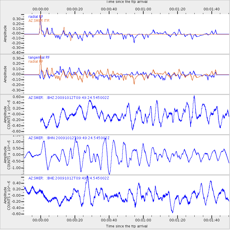
SMER AZ.SMER - Earthquake Result Viewer
*The percent match for this event was below the threshold and hence no stack was calculated.
| Earthquake location: |
Santa Cruz Islands |
| Earthquake latitude/longitude: |
-12.4/166.5 |
| Earthquake time(UTC): |
2009/10/12 (285) 09:37:21 GMT |
| Earthquake Depth: |
42 km |
| Earthquake Magnitude: |
5.9 MB, 5.9 MS, 6.2 MW, 6.2 MW |
| Earthquake Catalog/Contributor: |
WHDF/NEIC |
|
| Network: |
AZ ANZA Regional Network |
| Station: |
SMER AZ.SMER |
| Lat/Lon: |
33.46 N/117.17 W |
| Elevation: |
355 m |
|
| Distance: |
85.7 deg |
| Az: |
54.553 deg |
| Baz: |
252.174 deg |
| Ray Param: |
$rayparam |
*The percent match for this event was below the threshold and hence was not used in the summary stack. |
|
| Radial Match: |
56.57329 % |
| Radial Bump: |
400 |
| Transverse Match: |
62.1855 % |
| Transverse Bump: |
400 |
| SOD ConfigId: |
2622 |
| Insert Time: |
2010-02-26 20:48:55.147 +0000 |
| GWidth: |
2.5 |
| Max Bumps: |
400 |
| Tol: |
0.001 |
|
Signal To Noise
| Channel | StoN | STA | LTA |
| AZ:SMER: :BHN:20091012T09:49:24.545002Z | 4.125584 | 6.888727E-7 | 1.6697581E-7 |
| AZ:SMER: :BHE:20091012T09:49:24.545002Z | 0.8650401 | 1.452186E-7 | 1.67875E-7 |
| AZ:SMER: :BHZ:20091012T09:49:24.545002Z | 1.5303583 | 3.197158E-7 | 2.0891567E-7 |
| Arrivals |
| Ps | |
| PpPs | |
| PsPs/PpSs | |


