You are here: Home > Network List > KN - Kyrgyz Seismic Telemetry Network Stations List
> Station CHM KN.CHM > Earthquake Result Viewer
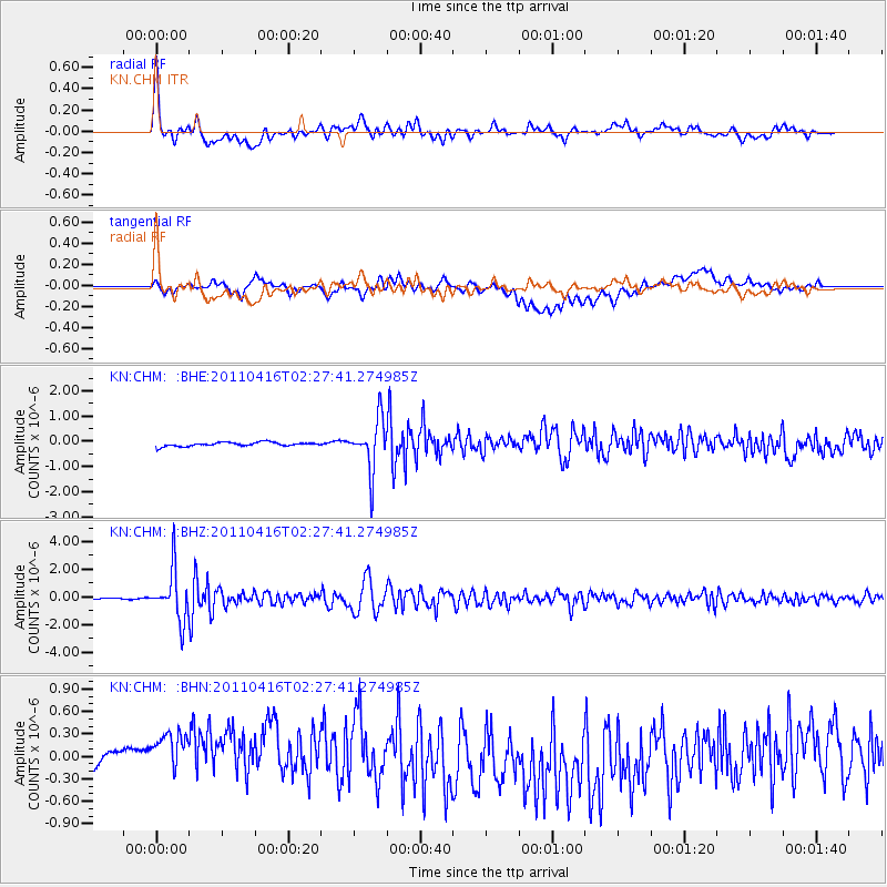
CHM KN.CHM - Earthquake Result Viewer
*The percent match for this event was below the threshold and hence no stack was calculated.
| Earthquake location: |
Eastern Honshu, Japan |
| Earthquake latitude/longitude: |
36.4/139.7 |
| Earthquake time(UTC): |
2011/04/16 (106) 02:19:30 GMT |
| Earthquake Depth: |
77 km |
| Earthquake Magnitude: |
5.9 MB, 5.8 MW, 5.8 MW |
| Earthquake Catalog/Contributor: |
WHDF/NEIC |
|
| Network: |
KN Kyrgyz Seismic Telemetry Network |
| Station: |
CHM KN.CHM |
| Lat/Lon: |
43.00 N/74.75 E |
| Elevation: |
655 m |
|
| Distance: |
49.3 deg |
| Az: |
298.759 deg |
| Baz: |
74.649 deg |
| Ray Param: |
$rayparam |
*The percent match for this event was below the threshold and hence was not used in the summary stack. |
|
| Radial Match: |
79.77593 % |
| Radial Bump: |
400 |
| Transverse Match: |
42.019424 % |
| Transverse Bump: |
400 |
| SOD ConfigId: |
356183 |
| Insert Time: |
2011-09-30 04:21:39.192 +0000 |
| GWidth: |
2.5 |
| Max Bumps: |
400 |
| Tol: |
0.001 |
|
Signal To Noise
| Channel | StoN | STA | LTA |
| KN:CHM: :BHZ:20110416T02:27:41.274985Z | 27.495901 | 1.7753817E-6 | 6.456896E-8 |
| KN:CHM: :BHN:20110416T02:27:41.274985Z | 1.8416775 | 6.7214796E-7 | 3.6496505E-7 |
| KN:CHM: :BHE:20110416T02:27:41.274985Z | 12.976684 | 9.916807E-7 | 7.64202E-8 |
| Arrivals |
| Ps | |
| PpPs | |
| PsPs/PpSs | |


